Tropical Disturbance likely to organize in the Caribbean and could be a threat to the US next week
Tonight and tomorrow, the disturbance will track across the extreme southern Caribbean islands including Trinidad and Tobago bringing gusty winds and tropical downpours.
The podcast Tracking the Tropics with Bryan Norcross is now available to stream.
(FOX Weather)
Updated at 8:30 a.m. Eastern
Tropical Disturbance #1 is in an unfortunate position. It's far enough south that it's less likely to turn north until it reaches the western Caribbean. If it arcs to the north from below Cuba, it could threaten the Gulf coast, Florida, or the Bahamas. It will likely organize into a tropical depression over the next couple of days, at which time we'll get a forecast cone from the National Hurricane Center.
Tonight and tomorrow, the disturbance will track across the extreme southern Caribbean islands including Trinidad and Tobago bringing gusty winds and tropical downpours.
Until the weekend, hostile upper-level winds emanating from Hurricane Fiona are forecast to impact the system. That factor should slow any development, but it's probably not enough to keep the disturbance from organizing into at least a depression. As the system moves farther west in the Caribbean, however, the atmospheric environment is forecast to markedly improve. That, combined with the exceptionally warm water in the western Caribbean Sea, should allow the system to further organize and strengthen.
The various computer forecast models agree that the system will track across the Caribbean for the next few days. Then there is a decent chance it will evolve into a tropical storm or hurricane as it begins its turn north.
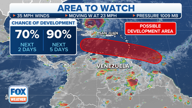
A tropical disturbance east of the southeastern Caribbean islands has a high chance of development.
(FOX Weather)
The graphic below shows the diversity of possible tracks. This is a way to visualize the uncertainty in the forecast. Notice the zone of concern extends from the Gulf to the Bahamas east of Florida.
This range of possibilities is normal for a system in its initial stages of development. The rule that forecast errors are highest for disorganized or just-developing systems applies. This visualization gives us an idea of the areas that need to stay fully aware of changes as the forecast evolves.
The differences in the various tracks are related to the forward speed of the system, how quickly it intensifies, how far north it tracks, plus the exact orientation of the dip in the jet stream that could scoop it north. The various combinations of these variables give us the diversity of possible long-range tracks.
If the storm were to form and move toward the U.S., it would likely not be an issue until at least Tuesday of next week, depending on its track.
At this point, do not focus on any tracks you see on the internet. The system has only begun to develop, and many factors are in play. The best anyone can do in the potentially affected areas is to stay informed.
Hurricane Fiona has intensified into a Category 4 monster. It now appears it will track west of Bermuda by a decent amount. The closest National Hurricane Center forecast point is almost 150 miles offshore. The Bermuda Meteorological Service has issued a Tropical Storm Watch for the island. Impacts will begin tomorrow and last into Friday.
Fiona continues to drag an enhanced tropical moisture flow over Puerto Rico and the Dominican Republic. Some tropical downpours will still occur for the rest of the week, but there will be plenty of clear times as well.
About Saturday, Fiona will reach the Maritime Provinces of Canada, Nova Scotia and Newfoundland. The hurricane will merge with a northern disturbance to form a large and powerful North Atlantic storm. The Canadian Hurricane Centre is already alerting residents there of a potentially severe storm possessing both tropical and intense winter-storm-type properties but with very heavy rainfall.
Fiona will produce very large ocean waves and dangerous surf from Florida to New England late in the week, as energy in the Atlantic waters from the storm's powerful winds reaches the coast.
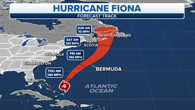
Fiona is a powerful Category 4 hurricane.
(FOX Weather)
Tropical Storm Gaston somewhat suddenly formed out of a disturbance in the middle of the Atlantic. It is forecast to intensify to near hurricane strength and then quickly weaken. It might affect the northernmost Azores, islands in the northeastern Atlantic, but as a relatively weak system. Gaston is only expected to last a few days.
Tropical Disturbance #2 has flared up a bit in the eastern tropical Atlantic. The NHC is giving it a slight chance of developing into at least a tropical depression. It's not expected to affect land at the current time.
Disturbance #3 is forecast to move off Africa tomorrow or Thursday. Some computer forecast models develop it quickly as it tracks to the north off the African coast, while others ignore it. In any case, it's not expected to be a threat to land.
Mother Nature is reminding us that it's the heart of hurricane season. What happened in the first part the season is not relevant, except that the ocean waters are warmer than they might have been because they weren't stirred up by previous storms. This is an important time to stay informed.
FOX Weather Hurricane Specialist Bryan Norcross has a podcast, Tracking the Tropics with Bryan Norcross, available now on FOX News Audio. You can get it on your device by clicking here.