Tropical development still possible in the Gulf of Mexico while we wait on the Atlantic
A tropical disturbance over Central America will move into the extreme southern Gulf of Mexico on Friday. It should have about two days over the warm water of the Gulf before it moves inland over northern Mexico or South Texas.
The podcast Tracking the Tropics with Bryan Norcross is now available to stream.
(FOX Weather)
Updated: 8:40 a.m. EDT
A tropical disturbance over Central America will move into the extreme southern Gulf of Mexico on Friday. It should have about two days over the warm water of the Gulf before it moves inland over northern Mexico or South Texas. There’s some chance it will organize into at least a tropical depression, although there is dry air in the area and part of the system might be over the land. By Sunday, its opportunity for development will be over.
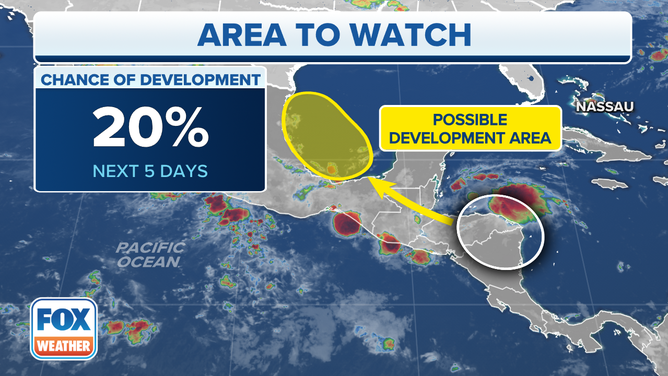
The National Hurricane Center is monitoring the Bay of Campeche in the southwestern Gulf of Mexico for possible tropical development over the next five days.
(FOX Weather)
Nothing dramatic is expected from this system, though heavy rain is possible when it moves inland.
The tropical Atlantic is expected to remain calm this week, but the consensus of the long-range computer forecast models is that systems moving off Africa will find enough moist air to have a chance to develop fairly soon.
A disturbance that just moved off Africa might moisten the atmosphere over the tropical Atlantic enough to start to develop around the first of next week, or it might lay the groundwork for systems behind it. In any case, there are signs the Atlantic is waking up.
Tropical activity has been below average this season, but not bizarrely so. The first hurricane develops, on average, on August 11th. If that’s the average date, sometimes developments are later to compensate for the years when a hurricane forms in June.
FOX Weather Hurricane Specialist Bryan Norcross has a podcast, Tracking the Tropics with Bryan Norcross, available now on FOX News Audio. You can get it on your device by clicking here.