Tropical Depression Nine forms in the Caribbean and aims toward Florida
Right now, the National Hurricane Center is forecasting the system to be a strong Category 2 hurricane at landfall in Florida. This means that all planning has to assume it could be at least a Category 3. We always assume at least a one-category error this far in advance.
The podcast Tracking the Tropics with Bryan Norcross is now available to stream.
(FOX Weather)
Updated at 8:30 a.m. ET
Tropical Depression Nine formed out of the disturbance we've been following in the Caribbean. It appears that the hostile upper-level winds that were limiting development let up just enough for thunderstorms to form near the center of rotation. The fact that we now have a well-defined center helps the forecasting. The computer forecast models have a better starting point to latch onto.
Now that the system is a tropical depression, we get a cone from the National Hurricane Center. Hopefully, that will get more people in Florida to pay close attention to the potential threat, which is harder to accomplish for a disorganized disturbance on the other side of the Caribbean Sea.
The NHC cone shows the threat zone as the Florida peninsula. The cone is a compromise of the key computer forecast models, some of which show landfall close to Tampa Bay and others that take the storm closer to Miami. A consensus of the models – in other words, a kind of average – is historically the most accurate predictor of where the storm is going to go.
But there are a couple of important points. Bear in mind that, on average, the center of the storm stays inside the cone about 2/3 of the time. And when a system is just forming, forecasts are poorer, so the accuracy is even less.
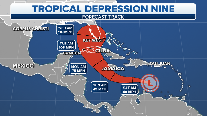
The projected path and intensity of Tropical Depression Nine.
(FOX Weather)
While the current cone is the best estimate of the system's track based on the available information. As the depression gets better developed and turns into a tropical storm with a well-defined center, the forecasts should improve, and we can have more confidence in the cone. The point is that we should expect adjustments in the coming days.
The timeline with this storm is compressed. It's not like when Irma was approaching when we watched the storm's progress for more than a week. Plans are going to have to be implemented in a hurry.
If the storm were to move toward the Keys and extreme South Florida, the current timeline puts the storm there as early as Tuesday. If it were to move toward Central Florida, it would be more like Wednesday. If it went outside the cone to the northern Gulf coast, it would arrive on Thursday plus or minus.
The timeline is subject to change, of course, but it's unlikely to be radically different.
A strong jet-stream dip is forecast to reach the Gulf of Mexico Sunday and Monday. That feature should scoop up the storm and arc it north and east. Since we don't know exactly where the system will be when the dip grabs it, we don't know exactly where the arcing track will end up.
People in the northern Bahamas should also monitor the progress of the system.
The water is very warm on the storm's track. There is no obvious reason it won't steadily intensify. The only inhibiting factor would seem to be whether the upper-level winds are conducive. The forecast shows the environment as essentially ideal for intensification before the system gets to Cuba. In the Gulf, some dry air might come into play as well as slightly more hostile winds. But if the storm intensifies significantly, that might not be a factor. Strong storms can better throw off outside influences.
Right now, the National Hurricane Center is forecasting the system to be a strong Category 2 hurricane at landfall in Florida. This means that all planning has to assume it could be at least a Category 3. We always assume at least a one-category error this far in advance.
If you live in the threat zone, do your friends and neighbors a favor and be sure they are paying attention.
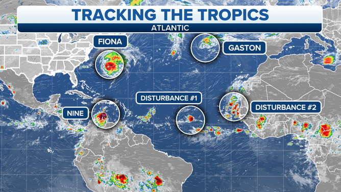
Hurricane Fiona is now just past Bermuda on its way to eastern Canada. The Canadian weather service is warning that Fiona is shaping up to be a severe event for Atlantic Canada and eastern Quebec. A large area will experience hurricane-force winds. Strong storms are not uncommon there, but normally they are in the winter when there are no leaves on the trees. Prolonged and widespread power outages are predicted.
Tracking the tropics
(FOX Weather)
Flooding is also possible from continuous rain, and the coastline will be battered by waves over 30 feet, causing significant erosion in some areas.
This is all forecast to begin later today and continue into Saturday.
Tropical Storm Gaston is doing a loop over the northern Azores - islands in the northeast Atlantic. The storm isn't terribly strong, but it is going to be relentless.
Tropical Disturbance #1 is a disorganized mass of showers. It has a slight chance of developing into a tropical depression.
Tropical Disturbance #2 is a robust system in the waters just off the African coast. It has a good chance of developing into at least a depression as it moves to the north.
Tropical Disturbances #1 and #3 are in a race to get named first. The next name on the list is Hermine, and the one after that is Ian.
Stay well-informed in the Florida threat zone to be sure you have the latest information. Things will develop quickly over the next few days.
FOX Weather Hurricane Specialist Bryan Norcross has a podcast, Tracking the Tropics with Bryan Norcross, available now on FOX News Audio. You can get it on your device by clicking here.