There are tropical disturbances to watch, but development appears unlikely this week
By late September, our focus on the eastern Atlantic usually winds down, and we shift our attention to the waters of the western Caribbean and the southern Gulf.
The podcast Tracking the Tropics with Bryan Norcross is now available to stream.
(FOX Weather)
Updated at 9:50 a.m. Eastern
The odds are that the unusually parched atmosphere over the Atlantic will inhibit development of either of the two robust disturbances this week, but there’s not a zero chance. The dry air combined with bands of hostile upper winds has thwarted attempts at organization for most of the disturbances coming off Africa this year. The moisture has been concentrated in the western Caribbean and the southern Gulf of Mexico.
Tropical Disturbance #1 is a large area of disorganized weather over the central tropical Atlantic. There is good consensus in the computer forecast models that it will move through the northeastern Caribbean islands late in the week, most likely as a moisture surge. Gusty tropical downpours will likely accompany passage of the disturbance.
HOW TO WATCH FOX WEATHER ON TV
The disturbance appears to have a brief window of time to develop some organization on its trip toward the islands. The National Hurricane Center is giving it a low chance of becoming a tropical depression over the next 5 days.
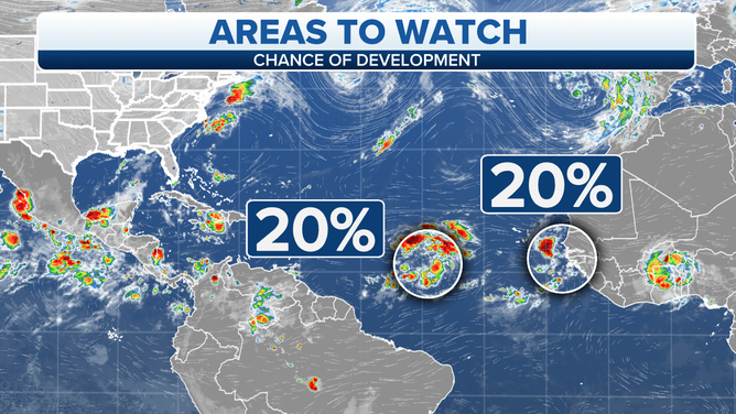
The circled areas are being monitored for possible tropical development in the Atlantic.
(FOX Weather)
Tropical Disturbance #2 just moved off the coast of Africa. It shows some early signs of organization, but a surge of dry air is just north of the disturbance, which will likely make development difficult. This disturbance is forecast to move through the Cabo Verde Islands just off the African coast as a moisture surge, then pull north and dissipate in the central Atlantic.
Just in case the system can find a conducive patch of atmosphere along the way, the National Hurricane Center is also giving this system a slight chance of developing.
By late September, our focus on the eastern Atlantic usually winds down, and we shift our attention to the waters of the western Caribbean and the southern Gulf. A broad area of low pressure technically called the Central American Gyre – a gyre being a large rotating system – often straddles from the Caribbean and Gulf across the land mass to the Pacific.
HOW TO DOWNLOAD THE FOX WEATHER APP
So far this year, systems that have spun out of this broad low-pressure area have developed in the Pacific Ocean, but with so much moisture and generally low pressure in place, this area will bear watching.
But for now, the odds of any development are low.
FOX Weather Hurricane Specialist Bryan Norcross has a podcast, Tracking the Tropics with Bryan Norcross, available now on FOX News Audio. You can get it on your device by clicking here.