Bryan Norcross: Systems are spinning north in the Atlantic but not in the tropics
The National Hurricane Center is giving Invest 96L a high chance of developing over the next couple of days. By the end of the week, its opportunity will likely end.

FOX Weather is your Hurricane HQ, streaming free 24/7.
(FOX Weather / FOX Weather)
UPDATED Monday at 8:50 a.m.
The tropical disturbance in the central Atlantic is already producing winds over 40 mph. So the National Hurricane Center will name it if it can pull itself together sufficiently to be categorized as a tropical storm. The system’s official name is Invest 96L, which means the NHC is investigating it with additional computer forecast models.
The system has a clear and robust circulation, but upper-level winds are pushing the thunderstorms to the east side. If the winds let up a bit, and the thunderstorms can wrap around the system, it will meet the criteria to be upgraded.
The National Hurricane Center is giving the disturbance a high chance of developing over the next couple of days. By the end of the week, its opportunity will likely end.
In any case, the system is not a threat to land.
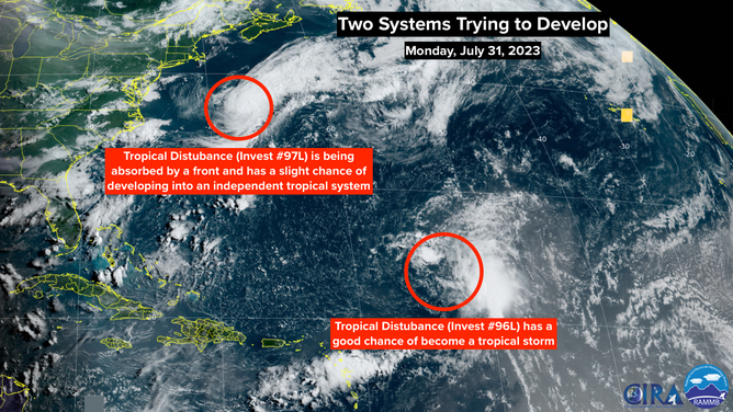
NOAA satellite images of two disturbances in the Atlantic.
(FOX Weather)
Well offshore of the Mid-Atlantic coast, another disturbance is being investigated – Invest 97L. It’s also likely to soon contain 40 mph winds, but this one has a very small chance of becoming a tropical storm. It is being absorbed by a cold front that moved off the East Coast of the U.S., significantly lowering the temperatures in the big cities along the I-95 corridor.
One of the requirements for a system to be called "tropical" is that it not be connected to fronts. A front is a line dividing warm and cold air. It’s that contrast that powers non-tropical storms like nor’easters. Tropical systems run off the heat from the ocean.
There’s only a slight chance and a very brief window for the disturbance to develop independently of the frontal system, and that window is closing fast. In any case, it’s moving offshore and isn’t a threat.
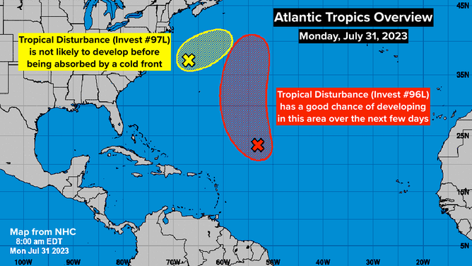
Invest 96L and Invest 97L in the Atlantic.
(FOX Weather)
In the tropical Atlantic between Africa and the Caribbean, where most of the big storms originate, there is nothing to look at. A large plume of thick Saharan dust is forecast to stick around into next week at least. This will keep the middle levels of the atmosphere dry and limit any tropical development.
Elsewhere, hostile upper-level winds are forecast to keep things quiet. On average, the hurricane season doesn’t heat up until the middle of August. A calm end of July isn’t unusual.