Potential Caribbean system will be slow to develop
An unusually deep and sharp dip in the jet stream is scooping moisture from a weak tropical disturbance that moved into the Caribbean Tuesday and is pumping it toward the islands. This convergence of weather systems will only slowly abate, so a very rainy stretch is forecast this week.
The podcast Tracking the Tropics with Bryan Norcross is now available to stream.
(FOX Weather)
Updated at 9:30 a.m. ET
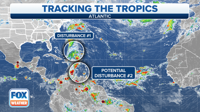
The weather pattern across the Atlantic and the Caribbean Sea reflects the changing of the season. Both areas we're watching for development have components of a typical tropical disturbance, but there's a strong dip in the jet stream from the north involved as well. These hybrid development scenarios are typical for this late in October.
Potential Tropical Disturbance #2 has not yet developed, but it's the most interesting because it has a decent chance of affecting land sometime next week. Some of its ingredients are already drenching Puerto Rico and the Virgin Islands with a fire hose of moisture running south to north across the Caribbean. Nearly a foot of rain is forecast over the higher elevations of the islands over the next few days, with the possibility of significant flooding when the water runs downhill.
An unusually deep and sharp dip in the jet stream is scooping moisture from a weak tropical disturbance that moved into the Caribbean Tuesday and is pumping it toward the islands. This convergence of weather systems will only slowly abate, so a very rainy stretch is forecast this week.
Over the weekend, yet another weak tropical disturbance will cross into the Caribbean from the Atlantic. The consensus of the computer forecast models is that the combination of a reinforced jet-stream dip and the new disturbance will slowly generate an organized tropical low-pressure system in the southern Caribbean about Sunday.
HOW TO WATCH FOX WEATHER ON TV
The National Hurricane Center is putting the odds of that happening in the low range through the weekend. But the consensus of the long-range computer models is that something will develop beyond that time period next week.
2 AM Atlantic Tropical Overview
(FOX Weather)
All indications are that any system that develops will be blocked from turning north by a broad area of high pressure over the Gulf and Florida. According to the current long-range projections, the flow around the high would push the system west in the direction of Central America.
We're talking about a week from now or more, and forecasts can change, of course. In fact, this scenario is doubly uncertain. First, development isn't likely for several days, and long-range forecasts are always iffy. And forecasts for systems that haven't yet developed are always subject to change.
So for now, we'll keep an eye on developments, especially for our friends around the southern Caribbean.
Disturbance #1 is an elongated area of low-pressure east of the Bahamas. Over the next few days, there's a fair chance that the same dip in the jet stream that's currently blasting Puerto Rico with tropical moisture might trigger a hybrid-type low-pressure system over the open ocean off the southeastern U.S.
These hybrid systems are designated subtropical depressions or storms if they develop. In any case, it does not appear to be a threat to land.
Nothing else seems to be in the works.
FOX Weather Hurricane Specialist Bryan Norcross has a podcast, Tracking the Tropics with Bryan Norcross, available now on FOX News Audio. You can get it on your device by clicking here.