Bryan Norcross: Philippe and Rina sitting in a tree… K-I-S-S-I-N-G
When two equally well-developed systems get close to each other, they rotate around a center point in a counterclockwise direction. It’s called the Fujiwara effect for a Japanese meteorologist who identified the phenomenon more than 100 years ago.

FOX Weather is your Hurricane HQ, streaming free 24/7.
(FOX Weather / FOX Weather)
Updated at 8:40 AM by Bryan Norcross
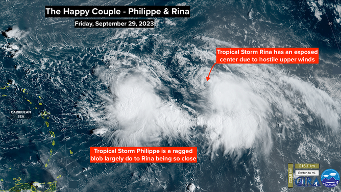
A super-unusual and hard-to-predict two-storm scenario is playing out in the tropical Atlantic east of the Caribbean. Tropical Storm Philippe was lolling along minding its own business when Tropical Storm Rina staged an attack on its rear flank. The circulations and wind flow in and around the two storms are interacting to neither storm’s benefit. But both storms are hanging on as tropical storms while doing the do-see-do.
When two equally well-developed systems get close to each other, they rotate around a center point in a counterclockwise direction. It’s called the Fujiwara effect for a Japanese meteorologist who identified the phenomenon more than 100 years ago.
In this case, Philippe is being deflected to the south and Rina to the north. The interaction can also weaken or kill off one of the systems if dry air or the hostile winds related to the interaction become too much. Two tropical storms are never exactly equal, and with two relatively weak systems, it’s impossible to predict in what ways one or the other might dominate the dance.
NOAA satellite view of Tropical Storm Philippe and Tropical Storm Rina on September 29.
(NOAA)
In any case, the high likelihood is that Rina will either die off or eventually shoot to the north into the open Atlantic. There are more possibilities with Philippe.
The odds favor Philippe hanging out east of the Caribbean islands until a strong dip in the jet stream comes along and scoops it away to the north. This is thinking is reflected in the National Hurricane Center's forecast cone. But that’s not 100%.
If the interaction with Rina, relatively dry surrounding air, and hostile upper winds weaken Philippe enough, it could miss the ride on the jet-stream scoop and drift toward the islands. If that were to happen, all indications are that Philippe or what’s left of it would be weak, so the threat would be minimal.
Eventually, it appears the upper-level wind flow will become conducive for strengthening. Assuming Philippe survives to take advantage of the supportive atmospheric pattern, it should be well away from the islands, but that’s not 100%.
Nothing is going to happen fast. The steering currents are very weak. Everybody in Puerto Rico and the surrounding islands should stay informed over the next few days to be sure nothing surprising happens.
There’s a rule that says that forecasts for systems that are slow-moving or just-developing have larger-than-normal errors. Add the giant forecast-error maker of another storm on the back porch, and extra vigilance is required until things sort themselves out.
Nothing else appears to be on the horizon.