Nicole weakens over Florida, but there’s a disruptive day ahead in part of the state
Extremely high water and flooding are forecast south of Jacksonville on the St. Johns River, where water leftover from Hurricane Ian is adding to the problems.
The podcast Tracking the Tropics with Bryan Norcross is now available to stream.
(FOX Weather)
Updated at 8:30 a.m.
Tropical Storm Nicole still has a giant circulation that extends hundreds of miles from the center. Winds are still blowing onshore along the east coast of Florida, which will prevent the coastal flooding from quickly receding, but overall the effects are diminishing.
Gusty winds and periods of heavy rain will cover the northern half of the Florida Peninsula and the Atlantic and Gulf coastal waters today, slowly tapering off tonight.
The wind and the saturated ground will likely cause power outages as trees come down due to weakened root systems. But no widespread outages are likely.
Hurricane Nicole made landfall near Vero Beach at about 3 a.m. ET. The storm tracked down the right side of the cone in those last several hours before reaching Florida. Since it went a little farther north, taking a longer path to land, it arrived a little later than it would have if it had come in farther south.
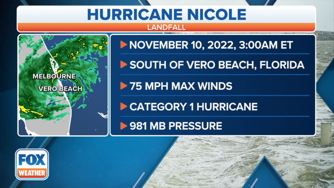
Nicole made landfall just south of Vero Beach, Florida, as a Category 1 hurricane at 3 a.m. Eastern on Thursday, Nov. 10, 2022.
(FOX Weather)
Fortunately, Nicole made landfall at approximately low tide. That took about 3 feet off the storm surge that came with the peak push of water into the coast. The ocean level was about 6 feet above its normal level near Cape Canaveral at about 4:00 AM this morning. That’s the only official tide gauge in Central Florida. We’ll see what the levels were at other places in the coming days.
Ocean water along the Central and North Florida coast is still high. Even though the effects from the storm are slowly diminishing, the high tide comes between 8:00 and 9:00 a.m., and will be about 3 feet above normal.
Extremely high water and flooding are forecast south of Jacksonville on the St. Johns River, where water leftover from Hurricane Ian is adding to the problems. Use extreme care in that area.
Tornados are also a threat in North Florida today, with the threat expanding north into Georgia and South Carolina later in the day. In addition, local coastal flooding will continue to be an issue in the Low Country for a couple more high-tide cycles.
Nicole will continue north out of Florida, and then its moisture will get absorbed into a cold front and upper-level system that will spread it into the Northeast and New England over the weekend.
If you’re in the affected areas today, just stay safe and let it pass. Good weather is coming when Nicole pulls away.
FOX Weather Hurricane Specialist Bryan Norcross has a podcast, Tracking the Tropics with Bryan Norcross, available now on FOX News Audio. You can get it on your device by clicking here.