Bryan Norcross: Keeping half an eye on the eastern Atlantic over the next week
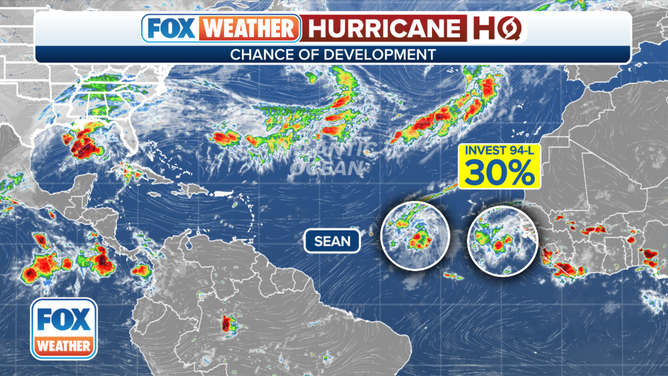
Sean is forecast to struggle as a depression before it dissipates in a few days. The tropical disturbance behind it, officially tagged Invest 94L, is a disorganized cluster of thunderstorms.

FOX Weather is your Hurricane HQ, streaming free 24/7.
(FOX Weather)
Updated at 9:15 a.m. EDT on Thursday
Tropical Depression Sean is fighting hostile upper-level winds as it drifts toward the open central Atlantic Ocean. Atmospheric conditions were marginally conducive for development part of the day yesterday, and the system organized enough to get named. That patch of supportive atmosphere appears to have moved on. Sean is forecast to struggle as a depression before it dissipates in a few days.

A satellite image of Tropical Depression Sean and Invest 94L on Thursday, October 12, 2023.
(NOAA)
The tropical disturbance behind it, officially tagged Invest 94L, is a disorganized cluster of thunderstorms. The steering currents are very weak over the Atlantic at the moment, which means neither the disturbance nor Sean will move very fast.
The consensus of the long-range computer forecasts is that the tropical disturbance will saunter in the general direction of the Caribbean islands for at least the next 7 days. The National Hurricane Center is giving it a low chance of becoming at least a tropical depression during that time.
An overview of the tropical Atlantic Ocean on Thursday, October 12, 2023.
(FOX Weather)
Because of its low latitude, we’ll keep an eye on the disturbance. Low-riding systems are less likely to be pulled north. On the current schedule, the disturbance would reach the vicinity of the islands at the end of next week. Whether it would be an organized system or just a moisture surge at that time is an open question.
It would be unusual, but not unheard of, for a system to develop in the tropical Atlantic this time of year. There’s no indication of a significant threat for now, but we’ll watch to be sure.