Keeping an eye on the Gulf and looking for signs of life in the Atlantic
The tropical disturbance over Central America has a chance of briefly developing into a tropical depression or tropical storm when it moves over the extreme southern Gulf of Mexico tomorrow and Saturday.
The podcast Tracking the Tropics with Bryan Norcross is now available to stream.
(FOX Weather)
Updated: 8:10 a.m. EDT
The tropical disturbance over Central America has a chance of briefly developing into a tropical depression or tropical storm when it moves over the extreme southern Gulf of Mexico tomorrow and Saturday.
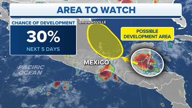
The National Hurricane Center is monitoring the Bay of Campeche in the southwestern Gulf of Mexico for possible tropical development over the next five days.
(FOX Weather)
The slice of the Gulf that looks conducive to development is quite small. If the disturbance tracks too far west, it will run over land. If it tracks farther into the Gulf, the upper-level winds are forecast to be hostile. Since it has to thread the needle to have any chance to develop, the National Hurricane Center is giving it a fairly low chance.
By Sunday, the system is likely to be inland in Mexico or South Texas as a moisture surge. Even if it did organize, there is no sign it would get terribly strong.
The tropical Atlantic has a faint pulse. It looks like it’s thinking about coming alive. The long-range computer forecast models show some activity next week, but there is no consistency in the projections. The main point is that surges of moisture seem to be more robust than they have been. When that happens, the leading surge or disturbance can moisten the atmosphere to make a more supportive corridor for the systems that follow.
There still is plenty of dry air lurking just to the north of a generally moister belt in the deep tropics, however.
We’ll watch for more consistency in the computer forecast models. Until then, we’ll just be grateful that, for whatever reason, the start of the heart of the hurricane season is delayed through the weekend, at least.
FOX Weather Hurricane Specialist Bryan Norcross has a podcast, Tracking the Tropics with Bryan Norcross, available now on FOX News Audio. You can get it on your device by clicking here.’