Kay’s rain and wind arrives in Southern California today while Earl moves away from Bermuda
Sept. 10, on average, is when we are most likely to have a named system in the Atlantic, and it looks like we will still have Earl. By Saturday, unless something unexpected happens, we’ll be named-system free.
The podcast Tracking the Tropics with Bryan Norcross is now available to stream.
(FOX Weather)
Updated 9:15 a.m. EDT
Tropical Storm Kay continues on track along the coast of Mexico’s Baja California. The center of the storm is forecast to stall and loop as it dies out over cooler water offshore of the Mexico/U.S border. Tropical moisture will continue to push north, however, which will end the record-setting heatwave in Southern California and produce heavy rain in some areas.
It’s an odd way to end a heatwave. In California, it’s hot when the wind comes off the desert and over the mountains into the city. When the cooling comes, usually the wind switches direction, so it comes from the west. Cool Pacific air is then pushed inland, and the hot air stays over the deserts. But in this case, the wind flowing into the highly-populated coastal areas will still come off the desert and over or through the mountains. But the clouds and rain will hold the temperature down starting tomorrow.
It will be unusually humid, however, by Southern California standards.
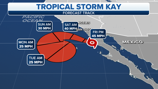
The projected path and intensity of Tropical Storm Kay.
(FOX Weather)
The rare inflow of tropical air will last into next week, though the heaviest rain is forecast to fall later today into tomorrow spreading from south to north.
The unusual weather pattern will cause the heaviest rain to fall in the deserts of extreme southern California and southwestern Arizona. The mountains just inland from the California coast will block the moisture flowing off the desert, causing the heaviest rain to fall over the normally arid inland areas. Some rain is expected over the coastal sections, but much less than well inland.
HOW TO WATCH FOX WEATHER ON TV
As the wind from the desert flows over the mountains and through the valleys toward the Pacific, in some valleys, the air will get squeezed like a garden hose and accelerate. So wind gusts up to hurricane force are expected near some mountain peaks and narrow passages, especially in San Diego County. In Greater Los Angeles, there will likely be some gusty winds, but the strong gusts are more likely farther south, closer to the center of what’s left of Kay.
A lot of the rain will be beneficial. California is suffering through a decades-long drought, but flash-flooding and mudslides are possible on the east and southeast-facing hillsides where too much rain may come at once. Up to 8 inches of rain is forecast for isolated areas east of and over the Southern California mountains, with more widespread amounts in the 3-to-5-inch range.
The effects of Kay will taper off on Sunday, and by mid-next week, typical weather will return to the Southland of California.
Hurricane Earl is now moving away from Bermuda, having made its closest approach overnight. Earl stayed well offshore, so the island only received tropical-storm-force winds, as forecast. Earl is continuing to strengthen, however, as it moves into the North Atlantic.
The storm is forecast to reach its peak strength today before beginning the process of merging with a non-tropical low-pressure system and dip in the jet stream overtaking it from the west. This non-tropical system is the one that brought the rain and ushered in cooler weather across the Northeast and New England.
The combo weather system is forecast to become a giant non-tropical system that will stall off the coast of Newfoundland, Canada, but close enough to produce high winds and heavy rains over the land.
HOW TO DOWNLOAD THE FOX WEATHER APP
The combo low-pressure system will eventually dissipate in the North Atlantic next week as it heads in the general direction of Europe.
Large swells emanating from Earl and eventually, the combo system will impact the U.S. East Coast for several days, making surf conditions dangerous.
In the central tropical Atlantic, Tropical Disturbance #1 has not been able to pull itself together, and it’s looking less like it will before it is pulled north behind Earl and dissipates. Winds over 40 mph have been measured well away from the circulation center, so if it can consolidate, it would be named Tropical Storm Fiona.
Hostile upper-level winds have torn it apart, separating the thunderstorms from the center. It’s still not impossible that they could let up enough for a brief period of organization, but the window of opportunity will close soon.
Tropical Disturbance #2 is a poorly organized cluster of showers in the far eastern Atlantic. A large area of dry air is just to the north. In 2 or 3 days, there is a slight chance the atmospheric environment will become conducive enough for the disturbance to organize, although the consensus of the long-range computer forecast models is that it will move across the Atlantic as a moisture surge.
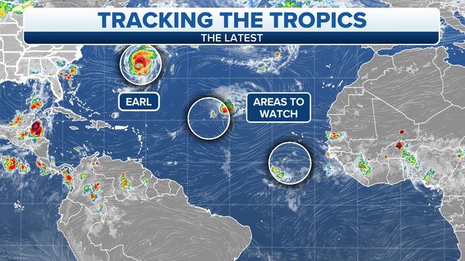
Activity in the tropics as of Friday, Sept. 9, 2022.
(FOX Weather)
The National Hurricane Center is giving it a low chance of developing in the next 5 days.
Tropical Disturbance #3 is still over Africa. It is forecast to cross into the Atlantic late in the weekend and will have an opportunity to organize a few days later. Again, the computer forecast models are not showing a lot of development, so for now, the National Hurricane Center is giving it a low chance of developing in the next 5 days.
Tomorrow is, on average, the date when we are most likely to have a named system in the Atlantic, and it looks like we will still have Earl. By Saturday, unless something unexpected happens, however, we’ll be named-system free.
Yes, it’s unusual, and no, there’s no ready explanation for the persistent dry air over the Atlantic plus the weather pattern that has turned the systems north. But, there are no complaints here.
FOX Weather Hurricane Specialist Bryan Norcross has a podcast, Tracking the Tropics with Bryan Norcross, available now on FOX News Audio. You can get it on your device by clicking here.