Bryan Norcross: Impacts from Hurricane Lee begin today and peak tomorrow in New England
On the current schedule, the wind will increase out of the north through the night into the morning in southeastern New England, with some rain arriving before sunrise and spreading north to Downeast Maine during the morning hours.

FOX Weather is your Hurricane HQ, streaming free 24/7.
(FOX Weather)
Updated at 9 a.m. ET Friday
This wind is already blowing on Cape Cod and Nantucket with the center of Hurricane Lee almost 500 miles to the south. It will be quite windy by mid-evening. Because the Cape and islands extend out into the ocean, the north wind generated by the giant storm is being felt there first.
On the current schedule, the wind will increase out of the north through the night into the morning in southeastern New England, with some rain arriving before sunrise and spreading north to Downeast Maine during the morning hours. Rain is expected to be mostly light, although the heavier band of rain will be just offshore of Cape Cod, so the highest chance of significant downpours will be in the easternmost parts of the Cape and islands.
Just the slightest deviation in the storm's track will make a huge difference in the amount of rain that falls on land areas.
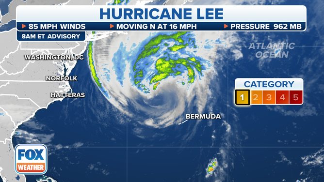
Hurricane Lee is on track to swipe New England with rain, strong winds and powerful surf this weekend.
(FOX Weather)
Over mainland sections east of the I-495 corridor around Boston and north along the I-95 corridor into New Hampshire and Maine, wind gusts to 40 or 50 mph could cause power outages. Good sense says to be prepared with batteries, charged devices, and enough food that you don't have to go out on Saturday. Just in case.
A Tropical Storm Warning is in effect for all of coastal Massachusetts and Maine reflecting the threat of winds over 40 mph.
The strongest winds and heaviest rain in the storm will be in Downeast Maine and western Nova Scotia, which will be closer to Lee's center track. Peak impacts should occur there tomorrow afternoon into the evening. The weather will dramatically improve Sunday from south to north.
The energy in the ocean from the broad sweep of Hurricane Lee's winds will peak along the Mid-Atlantic coast today. Extra-powerful waves and elevated water levels will cause beach erosion in some areas at high tide. Currents along the beaches and in inlets will be dangerously strong. Water levels in Long Island Sound could reach 3 feet above the normal high tide and 2 feet on the south shore of Long Island including on Fire Island. Use extreme caution.
Besides the energy from the swells emanating from the hurricane, strong north and northeast winds today will push water from Long Island Sound and Great South Bay in New York into the north-facing shorelines, which could damage low-lying structures. The threat will be most pronounced at high tide.
The peak ocean effects in the Gulf of Maine north of Cape Cod will occur tomorrow. Again, the biggest threat is at or near the time of high tide when the water could be up to 3 feet above normal levels. Some overwash is possible along much of the coast depending on the timing of the peak surge from the storm and how that coincides with the tide cycle.
Hurricane Lee will behave like a giant nor'easter, which New England should be able to deal with without too much trouble. The biggest difference is that the leaves are still on the trees, which means gusty winds to do more damage than in the winter. Downed tree limbs can take out power, thus the admonition to be prepared.
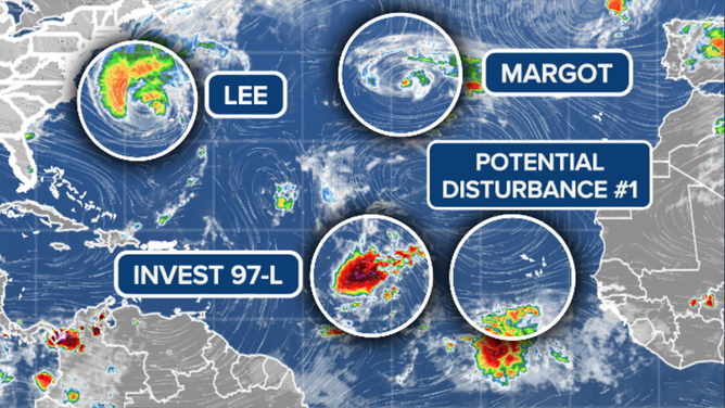
A disturbance over Africa can develop when it reaches the Atlantic next week.
(FOX Weather)
Elsewhere in the Atlantic, Tropical Storm Margot is spinning in circles and will die out soon.
The next Tropical Disturbance will likely develop into a tropical depression or Tropical Storm Nigel soon. The computer forecasts show it charging into the Western Atlantic on a path somewhat similar to Lee, although only Bermuda appears potentially threatened at this time.
A disturbance over Africa has a chance of developing when it reaches the Atlantic next week. We'll keep an eye on that, though there's no indication it would be a threat.