Ian is fading away while its flooding remains a big threat
The few leftover pockets of gusty winds will slowly wind down. The threat now switches to the effects of the rain that fell over the higher terrain in the Southeast and the record rainfall left behind in Florida.
The podcast Tracking the Tropics with Bryan Norcross is now available to stream.
(FOX Weather)
Updated at 10 a.m. Eastern
The circulation that was Hurricane Ian will die this weekend over North Carolina or Virginia. The few leftover pockets of gusty winds will slowly wind down. The threat now switches to the effects of the rain that fell over the higher terrain in the Southeast and the record rainfall left behind in Florida.
In a relatively flat place like Florida, the immediate effects of torrential rainfall are obvious – flooded roads, parking lots, etc. Eventually, much of that water reaches a river, however. But it takes time. That means the river flooding comes days or even a week after the big rains.
Ian dumped an incredible swath of rain across Florida from just north of Fort Myers through Orlando to Daytona Beach and the surrounding areas. Rain totals were 15 to 20 inches over wide area, with a few locations closer to 30 inches. All that water is causing major to record flooding on a number of rivers in Florida. The water levels will only slowly decrease next week as the drainage process continues.
The circulation that was <strong>Hurricane Ian </strong>will die this weekend over North Carolina or Virginia.
(FOX Weather)
A version of this is happening in the Carolinas as well. Although in hilly or mountainous terrain, it doesn’t take as much rain to cause rivers to swell since the water can more quickly run down the hill.
Beware of quickly rising water near rivers and streams until the crest passes. The timing will be different in different places.
Ian interacted with a front yesterday to produce the heavy rain across the south. All that’s left now is a large area of cold rain showers spreading across the Mid-Atlantic and the Northeast.
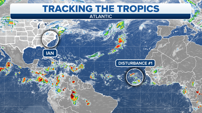
Elsewhere in the Atlantic, a robust Tropical Disturbance near Africa has a good chance of developing into Tropical Storm Julia. It is likely to turn north in the Atlantic, however, and does not appear to be a threat to land.
Now that it’s October, we’ll focus less on the tropical Atlantic Ocean and more on the Caribbean Sea and the extreme southern Gulf of Mexico where old cold fronts can stall and trigger tropical development.
Nothing looks threatening across the tropics right now.
FOX Weather Hurricane Specialist Bryan Norcross has a podcast, Tracking the Tropics with Bryan Norcross, available now on FOX News Audio. You can get it on your device by clicking here.