Bryan Norcross: This hurricane season feels like last year, but it's a different ballgame
Equating this year to last is tempting since we've seemingly hit a lull again. There is a similarity in the extensive dust and dry air over the tropical ocean, but the macro weather and ocean patterns are very different.

FOX Weather is your Hurricane HQ, streaming free 24/7.
(FOX Weather / FOX Weather)
UPDATED Monday at 10 a.m.
With last season's hyperactive September in our minds, it's hard to remember that August was quiet. Freakishly so. A combination of Saharan dust and dry air from the north kept disturbances moving off Africa from developing in the tropical Atlantic. Then on September 1, the typical atmospheric mechanisms that power the tropics kicked in with a vengeance.
Zero storms formed from July 3 to August 31. That has not happened since before World War II. Then four hurricanes and two tropical storms were named in September, including, of course, Hurricanes Fiona and Ian. Puerto Rico and near Fort Myers landfalls were 10 days apart.
Equating this year to last is tempting since we've seemingly hit a lull again. There is a similarity in the extensive dust and dry air over the tropical ocean, but the macro weather and ocean patterns are very different.
The combination of a developing warm tongue of water in the equatorial Pacific south of Hawaii – the phenomenon called El Niño – and the highly unusual distribution of super-warm water in the eastern Atlantic is unprecedented. How these two pools of high-temperature ocean will interact is difficult to predict.
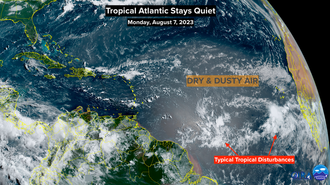
NOAA satellite image showing the Atlantic and dry Saharan dust.
(NOAA)
On average, El Niño years have fewer named storms, while years with a warm Atlantic have more. To what degree the extreme warming of the eastern Atlantic can counteract the negative influence of the warm El Niño pool is what seasonal forecasters are wrestling with.
Predictions from a variety of universities, agencies, and forecasting groups around the world range from a season with more or less average activity to one that would be one of the busiest on record. The range reflects the uncertainty intrinsic in the unique combination of ocean-temperature profiles.
Colorado State University's seasonal-forecasting group issued their final forecast of the year last week, calling for a total of 18 named storms, nine of them being hurricanes, four Category 3 or above. For perspective, that means the rest of the season would be slightly above average.
Since five named storms have come and gone – including a posthumously re-categorized storm in the North Atlantic last January – 13 storms would be left to form. According to the National Hurricane Center, 11 named storms form after today's date in an average year, so we're not talking about a crazy deviation. In addition, these days, we name one or two more storms each year anyway because of technological advances compared to the beginning of the official averaging period in the 90s.
There are eight hurricanes yet to form, according to the CSU forecast, compared to an average of seven. And four Category 3+ storms compared to an average of three. These numbers reflect the likelihood that the extra-warm eastern tropical Atlantic will help a couple of storms get stronger than they otherwise would have once the dry and dusty weather pattern lets up.
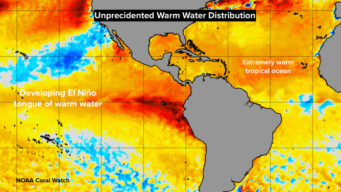
Water temperatures across the globe.
(FOX Weather)
Myriad questions abound, of course. The El Niño developing in the Pacific appears on pace to land in the moderate to strong category when it peaks later this year – a normal and expected process. The mass of super-warm water in the eastern Atlantic is not normal, however. And the water temperatures averaged across the whole planet have been at record levels.
Is the Atlantic phenomenon part of whatever is causing the widespread oceanic warming, or is it a different mechanism at work? Is the worldwide heat wave a tipping point or just a fluke caused by factors that happened to come together this year? These questions and more will draw a lot of analysis and discussion from the scientific community over the years to come.
While hurricanes will still be powered by heat from the ocean water, and the atmospheric factors that strengthen or weaken storms will be unchanged, the unknown is whether this very modern and unusual distribution of large pools of extremely warm water will change what's "normal" in a hurricane season in ways that aren't immediately obvious.