Bryan Norcross: Hurricane Hilary poses threats to Southern California while Atlantic systems stay on weak side
Hilary is forecast to peak out at Category 4 today before a weakening trend begins tomorrow. The storm is caught in an unusually strong river of air between the extreme high-pressure heat dome over the middle of the U.S. and an unseasonable low-pressure system off the California coast.

FOX Weather is your Hurricane HQ, streaming free 24/7.
(FOX Weather)
Updated Friday 8:45 a.m. EDT
Hurricane Hilary is intensifying even faster than forecast well southwest of the tip of Baja California. The worst of the storm will miss the Cabo San Lucas area, though they'll know an intense hurricane is passing by.
Hilary is forecast to peak out at Category 4 today before a weakening trend begins tomorrow. The storm is caught in an unusually strong river of air between the extreme high-pressure heat dome over the middle of the U.S. and an unseasonable low-pressure system off the California coast.
The flow between those weather systems has Hilary on a beeline toward Southern California. The ocean water temperature under the circulation will quickly drop as the hurricane moves north, so Hilary's winds are forecast to weaken significantly by the time it gets to the U.S./Mexico border. Large circulations like Hilary's take longer to spin down, however. A significant windstorm is possible in parts of San Diego, Imperial, Orange, Los Angeles, Riverside, and San Bernadino Counties.

Hurricane Hilary is intensifying even faster than forecast well southwest of the tip of Baja California.
(FOX Weather)
It's too early to know where the worst of the winds will occur because the mountain valleys and passes will funnel the wind, and the local wind speeds are very dependent on the exact direction of the wind. But heavy tropical rains will likely impact all of the southern part of California and the western parts of Arizona and Nevada. Flash flooding from heavy rain, especially over the mountains and in desert arroyos, is a real possibility.
The direction of the moisture-laden wind, when it runs into the various mountain ranges that crisscross Southern California, is also critical to where the heaviest rain will fall. And the wind direction in any one place is dependent on the exact track of the center of circulation.
On the current schedule, the rain moves in from south to north late Saturday, peaks Sunday into Monday in Southern California, moves north as a weaker rainmaker, and dies out Tuesday into Wednesday. Although some moisture will remain over California after the storm passes. Arizona and Nevada effects will be on a similar schedule. The moisture will rapidly spread north on Sunday.
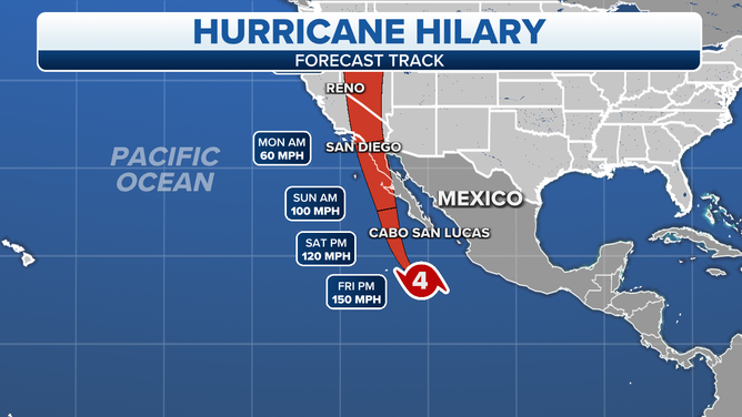
The worst of the storm will miss the Cabo San Lucas area, though they'll know an intense hurricane is passing by.
(FOX Weather)
If the center moves inland before reaching California, the heaviest rain will fall over the eastern-facing mountains and the deserts. If it tracks farther west and stays offshore longer, however, more rain will fall in the populated areas and west and south-fact slopes where millions of people live. It's too close to call.
This weekend it will be essential to stay informed in Southern California and in the population centers in Arizona and Nevada.
The Atlantic is buzzing with activity, but none of it is especially threatening. From left to right:
Tropical Disturbance #4 is near the Bahamas. The system will cross the southern part of the Florida peninsula on its way into the Gulf of Mexico. The National Hurricane Center is giving it a low chance of developing into a tropical depression on its trek across the Gulf over the weekend.
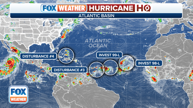
The Atlantic is buzzing with activity, but none of it is especially threatening.
(FOX Weather)
Whether it organizes or not, it could bring beneficial rain to at least parts of coastal Texas and the Hill Country around midweek. It's being driven west by the circulation around the ultra-strong heat dome high-pressure system over the central U.S. If the strong high flexes its muscles, the disturbance and its moisture might get pushed south so the Houston area, for example, only gets brushed. The breeze should also increase as the system tries to tighten up, and so will the humidity. Eastern Texas should get a break from the relentless 100+ degree heat.
In the eastern Atlantic, there are 3 disturbances embedded in an elongated area of disturbance weather. They all have a chance of developing into a tropical depression over the next few days, especially Invest 98L, the system farthest east.
Tropical Disturbance #1 (officially Invest #98L) is not a threat.
There's a chance the Tropical Disturbance #3, the one closest to the Caribbean islands, and possibly Invest #99L will track toward the Caribbean. With all these systems so close to each other and all captured in a broad area of disturbed weather across the tropical Atlantic, predictions about exactly what will happen are low confidence.
A lot of dusty dry air has spread across the Atlantic. Combined with upper winds that are hostile at times, the odds of development of the westernmost disturbance are low and medium for Invest #99L. Everybody on the northeast Caribbean islands should stay up to date on the latest forecasts over the next several days.
On the current schedule, the Tropical Disturbance #3 will move into the Caribbean over the weekend. The system is not expected to blow up into a major storm, but it could bring some gusty tropical downpours to some of the islands.
Some aspects of the atmospheric pattern over the Atlantic are very conducive for tropical development, and others are hostile. Right now, the hostile forces are winning. On average, the pendulum swings about this time, so we watch the disturbances closely to be sure a conducive patch of atmosphere doesn't suddenly open up. But for now, we are seeing a lot of systems but no atmospheric conditions like those supporting major Hurricane Hilary in the Pacific.
If you haven’t done it, download the FOX Weather app now. You’ll get alerts issued by the National Weather Service, plus you can stream FOX Weather by touching "Watch LIVE" in the upper right of the app’s home screen.
Be informed before you head out.