Bryan Norcross: Atlantic stays calm as Kiko weakens north of Hawaii
Tropical Storm Kiko is passing well north of the Big Island of Hawaii. Fringe moisture will likely cause a few extra showers and maybe a thunderstorm today and tomorrow as Kiko disrupts the typical trade wind flow over the islands.

FOX Weather is your Hurricane HQ.
(FOX Weather)
Updated at 8:30 a.m. ET on Tuesday, Sept. 9, 2025.
Broadly hostile conditions continue to dominate the Atlantic, Caribbean and Gulf. There are no signs of any tropical development this week, and development next week looks limited.
Long-range computer forecasts show a fairly robust disturbance moving off Africa at the end of the week, but the consensus so far is that it will either turn north or die out. Although, as we've learned, we can't put much stock into projections for a system that hasn't even formed.
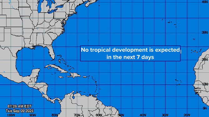
This graphic provides an overview of the tropical Atlantic Basin.
(FOX Weather)
In another couple of weeks, we'll start shifting our focus to the western Caribbean and the southern Gulf. As we saw last year with the development of hurricanes Helene and Milton, some years the important storms don’t come from the tropical Atlantic. Strong hurricanes can and do develop close to home in late September and October.
In the Pacific
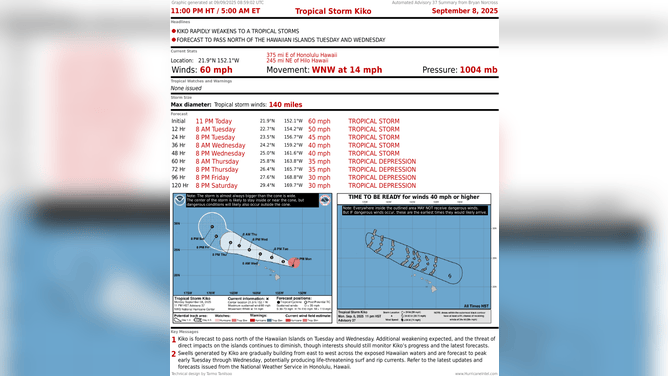
This graphic shows information on Tropical Storm Kiko.
(FOX Weather)
Tropical Storm Kiko is passing well north of the Big Island of Hawaii. Fringe moisture will likely cause a few extra showers and maybe a thunderstorm today and tomorrow as Kiko disrupts the typical trade wind flow over the islands. The storm is generating huge, dangerous waves on top of the extra high tide caused by the lunar cycle, so use care near the beaches.
The storm will continue to weaken as it passes the rest of the Hawaiian Islands tomorrow, and that will be that for Kiko.
On this date in 1965
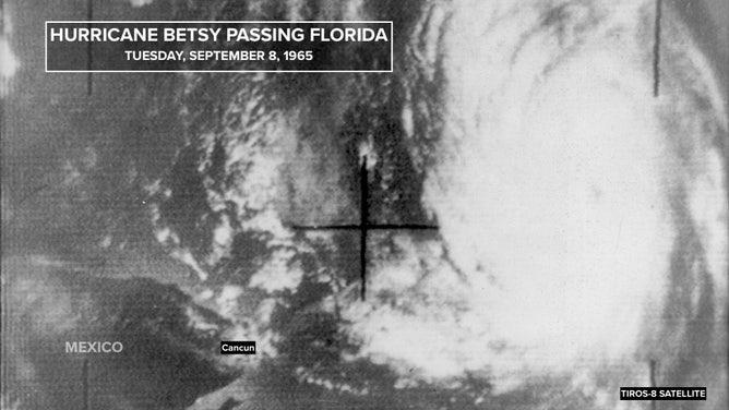
This satellite image shows Hurricane Betsy passing Florida in 1965.
(FOX Weather)
Hurricane Betsy had already shredded Nassau in the Bahamas and caused significant damage throughout the Miami metro before making landfall as a Category 4 south of New Orleans on Sept. 9, 1965 – 60 years ago today.
The broad circulation pushed Gulf water into the eastern side of the city, topping the levees and causing deadly flooding up to the eaves of homes in the Lower Ninth Ward and other neighborhoods near Lake Pontchartrain. The levee and flood wall system that failed 36 years later in Hurricane Katrina was constructed in response to the flooding from Betsy.
Forecasting Betsy had been a nightmare. The storm stalled and looped north of Puerto Rico before taking off on a track that had Miami on alert. Instead, the intensifying hurricane turned north. Hurricane Watches were discussed for North Carolina.
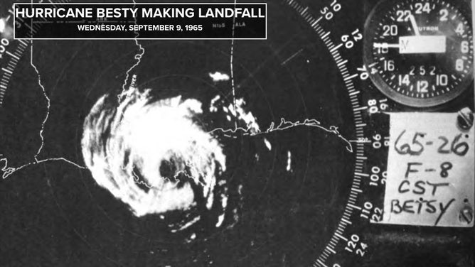
This is a satellite image of Hurricane Betsy making landfall in 1965.
(FOX Weather)
The Weather Bureau in Miami announced that the threat was over for South Florida, but Betsy stalled offshore of Cape Canaveral. It made another loop before heading back south, pounding Nassau as it crept through the Bahamas, then finally crossing Key Largo south of Miami on its way to the Gulf.
Beaches were scoured and coastal cities were flooded from Central Florida to Key West due to Betsy’s five-day crawl and stall east of the Florida Peninsula. Ocean waves crashed into hotels on Miami Beach. The Miami area zoo on Key Biscayne lost over 250 animals – drowned in the storm. It was the biggest Miami-area flood since the Great Miami Hurricane of 1926.
Betsy was the most expensive hurricane to that date – the first one to produce damage totaling over $1 billion.