Bryan Norcross: Dangerous swells to impact US East Coast from double hurricanes
Use extreme caution if you're thinking about going to the beach. The weather where you are might be nice, but inlets and harbor entrances could be dangerous for small boats because of the strong currents in the water.

FOX Weather is your Hurricane HQ.
(FOX Weather)
Updated at 9:45 a.m. ET on Tuesday, Sept. 30, 2025
Imelda has attained hurricane strength and has begun its turn out to sea away from Florida. Category 2 Hurricane Humberto is a little over 400 miles to the east. Together, they will generate dangerous swells that will impact the U.S. East Coast.
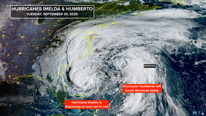
This satellite image shows Hurricane Imelda and Hurricane Humberto in the Atlantic on Sept. 30, 2025.
(FOX Weather)
Use extreme caution if you're thinking about going to the beach. The weather where you are might be nice, but inlets and harbor entrances could be dangerous for small boats because of the strong currents in the water.
Imelda is forecast to continue intensifying after it turns into the Atlantic. On the current track and schedule, it will be in the vicinity of Bermuda late tomorrow. A Hurricane Watch is in effect. Imelda’s top winds are forecast to be about 100 mph when it’s in the vicinity of the island.
Bermuda will be off the starboard wing (the right side) of Hurricane Humberto as it passes the island to the west and north from today into tomorrow. Gusty squalls are possible in the storm's outer bands. Then, Hurricane Imelda arrives later tomorrow. Yes, it's crazy.
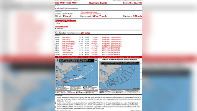
This image shows the latest information on Hurricane Imelda.
(FOX Weather)
Current forecasts call for Hurricane Imelda to come closer to Bermuda. The core of the hurricane with the strongest winds will be fairly small, and the island is really a speck in the vast ocean, so they'll have to be unlucky to get a direct hit. But as we've seen before, it can certainly happen.
After they pass Bermuda, both Humberto and Imelda will speed into the North Atlantic and become non-tropical systems.
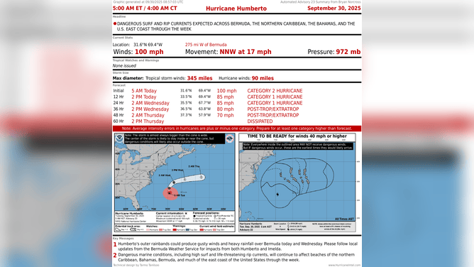
This image shows the latest information on Hurricane Humberto.
(FOX Weather)
Long-range computer forecasts show the possibility of one more system from Africa developing in the tropical Atlantic before the season shuts down. Early projections show it developing next week and moving in the general direction of the Caribbean islands. We'll keep an eye on it then.
Otherwise, there are no hints of tropical development for the next couple of weeks. But remember, this time of year, if something were to develop, it would most likely be in the western Caribbean or the southern Gulf, and we'd have less notice than we get with storms that form well out in the Atlantic.