Bryan Norcross: Florida, Southeast only feel edge effects from Imelda
Tropical moisture is streaming north from Imelda and interacting with the front along the Carolina coast. Rain will continue over coastal sections of the Southeast and inland over the Carolinas until the storm moves well out into the Atlantic tomorrow.

FOX Weather is your Hurricane HQ.
(FOX Weather)
Updated at 9:45 a.m. ET on Monday, Sept. 29, 2025
The center of Tropical Storm Imelda is just passing the northwestern Bahamas. It will proceed north, well offshore of the Florida coast through the day today. Outer bands will cause some gusty downpours along the coast. Boating conditions continue to be dangerous offshore.
Tropical moisture is streaming north from Imelda and interacting with the front along the Carolina coast. Rain will continue over coastal sections of the Southeast and inland over the Carolinas until the storm moves well out into the Atlantic tomorrow.
The National Weather Service is forecasting 1 to 2 inches of rain over coastal sections from North Florida up to the Carolinas, with some spots receiving up to 4 inches. Pay attention to flash flooding alerts that might be issued by your local National Weather Service office.
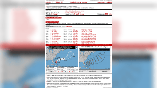
This graphic shows the latest with Tropical Storm Imelda on Sept. 29, 2025.
(FOX Weather)
The biggest threat from Imelda and powerful Hurricane Humberto just to its east will be powerful surf that the combination of the storms will generate. The strong swells will affect Florida and the Southeast today and then spread north of Cape Hatteras all the way to New England tomorrow and Wednesday. Pay attention to harbormasters and lifeguards if you’re thinking about boating or going to the beach.
Imelda is forecast to reach hurricane strength later tomorrow as it turns east away from the Florida coast. The storm will pass Bermuda about Thursday. It's too soon to know how strong the impacts will be, but it could be a close call.
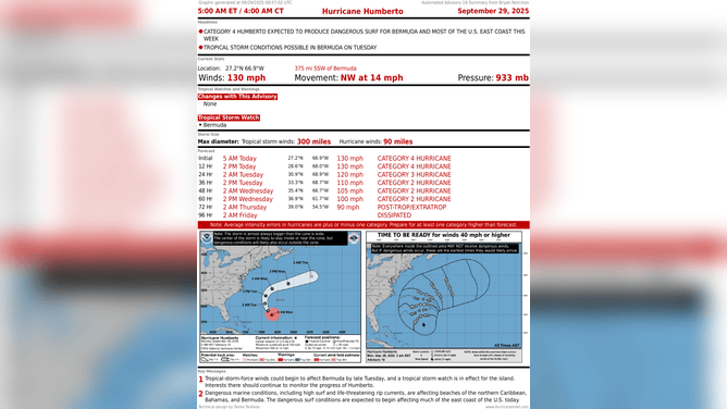
This graphic shows the latest with Hurricane Humberto.
(FOX Weather)
Only about 600 miles east of Imelda is Hurricane Humberto. Humberto is slowly weakening from its Category 5 peak, but it’s still formidable. It's also expanding in size. The timing between Humberto and Imelda just happened to work out so that Humberto would have its maximum interaction in time to keep Imelda from reaching the Carolina coast.
After today, Imelda is forecast to follow Humberto out to sea.
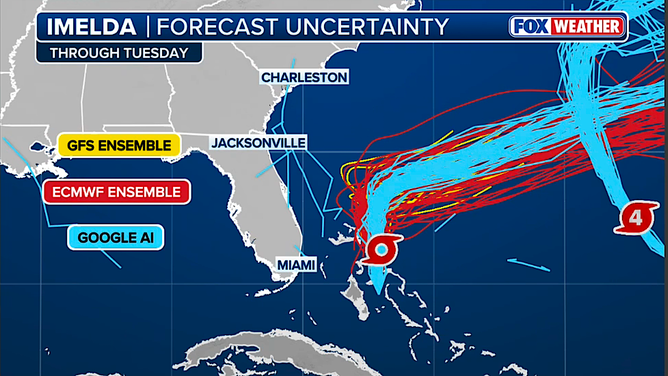
This graphic shows the forecast track of Tropical Storm Imelda from various computer forecast models.
(FOX Weather)
All the computer forecast models agree on this scenario, so we have high confidence. Here is the graphic showing the three families of computer forecasts: the U.S. GFS, the European and the Google DeepMind AI model. Each family generates multiple possibilities so that we have some understanding of the uncertainty intrinsic in the model and the atmosphere at this moment. When we see these fans of possibilities widen, we have lower confidence in the forecast.
This grouping of the three families is about as much agreement as you’ll ever see for a developing storm.
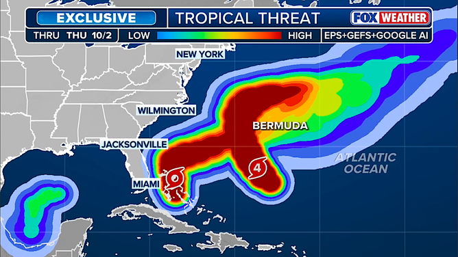
This graphic shows areas where tropical threats are highest in the Atlantic.
(FOX Weather)
There are 130 so-called members in these three families of forecasts. We look for the areas where there is the highest density of members. That tells us where the storm(s) are most likely to track. You see that here on the exclusive FOX Weather Tropical Threat Analysis in deep red.
This is all new. This is our first hurricane season comparing the AI models with the traditional computer forecasts, which are much more computationally intensive and expensive to run. Given the success of the Google DeepMind AI model this hurricane season, it's going to be interesting to see how the science evolves in the coming years.