Bryan Norcross: Imelda’s landfall unlikely in Southeast but rainfall impacts expected
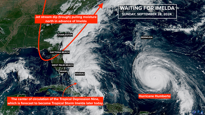
Hurricane Humberto is not expected to make landfall anywhere, but it is forecast to track close enough to future Tropical Storm Imelda to affect Imelda’s motion in a couple of days.

FOX Weather is your Hurricane HQ.
(FOX Weather)
Updated at 12:15 p.m. ET on Sunday, Sept. 28, 2025
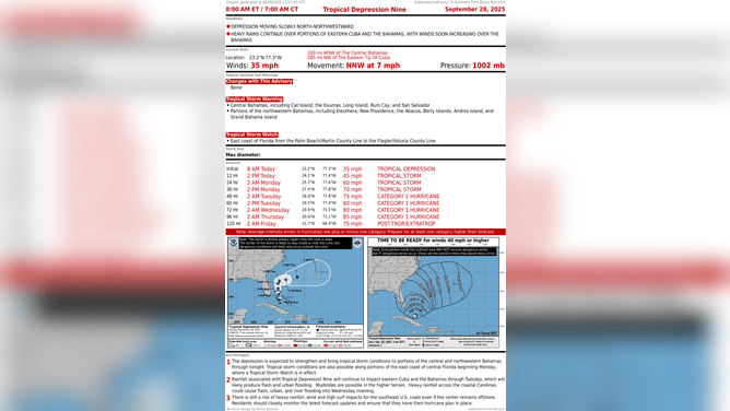
Tropical Storm Imelda is expected to form later today or early tomorrow from the depression we've been following near the central Bahamas. The system is forecast to steadily organize and intensify as it slowly moves north through the Bahamas and offshore of the Florida east coast.
Separately, farther east in the Atlantic, Hurricane Humberto reached Category 5 strength yesterday – the second Category 5 of the season. It’s now a Category 4. Fortunately, Humberto is not expected to make landfall anywhere, but it is forecast to track close enough to Tropical Storm Imelda to affect Imelda’s motion in a couple of days.
(FOX Weather)
Before that happens, as Imelda tracks north, its winds are forecast to remain below hurricane strength into tomorrow at least. The forecast track is close enough to the Florida coast, however, that gusty squalls could affect South Florida today. It’s going to be a close call whether the bands from Imelda reach land or just impact the coastal waters.
Boating will be dangerous today and tomorrow, and there will be extra energy in the ocean, so follow the lifeguards' instructions at the beach.
Later today and tomorrow, Imelda is forecast to steadily intensify, so winds could be stronger along the coast, especially north of the Palm Beaches. The National Hurricane Center has issued alerts for tropical-storm-force winds of over 40 mph. The wind will be especially noticeable right at the beach.
By Tuesday, when Imelda is well offshore of Central Florida, it's forecast to reach hurricane strength. About that time, the forward motion of the storm is expected to slow dramatically as the steering currents collapse due to Hurricane Humberto being in the general vicinity.
(FOX Weather)
Tropical moisture will still be pulled north across much of the Southeast through this period. Flooding is still possible from days of rain over top of saturated soil. Stay informed of local flood alerts that might be required from northeastern Florida through southeastern Georgia, the Carolinas and southeastern Virginia.
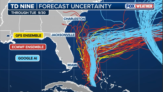
The forecast has shifted in a good way from Tuesday on. The expectation now is that likely-Hurricane Imelda will hang a hard right and head offshore. Landfall in the Carolinas or anywhere in the Southeast is no longer expected. Bermuda will have to watch carefully for potential impacts late Wednesday or Thursday.
The Google DeepMind AI model, which has performed well this year, led the way in predicting this dramatic turn out to sea yesterday, and now all the computer forecast guidance indicates a version of this dramatic shift in the track. As a result of the strong consensus of multiple computer forecasts, we have high confidence that a track something like this is likely.
(FOX Weather)
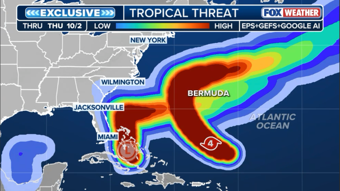
These days, we don’t look at individual models much at all. We look at the groups of forecasts that each computer forecast system produces. The goal of those groups of so-called ensembles is to present the range of possibilities that the various systems calculate. From these multiple possibilities, we look for consensus. The exclusive FOX Weather Tropical Threat graphic let us see those consensus calculations using the European, U.S. GFS and Google DeepMind AI models.
This is our first hurricane season looking closely at AI models, and it’s been a relatively quiet season, so we don’t have a lot of evidence. But so far, what we know is encouraging.
(FOX Weather)