Bryan Norcross: Latest computer forecasts show increased threat to Florida, Southeast from likely-Imelda
The bottom line is that everybody from South Florida to the Carolinas and Virginia, including the mountain areas, should stay in touch with the latest developments. And it’s important to remember that forecasts for just-developing systems are always subject to large errors and are likely to change.

Odds of Invest 94L developing into tropical depression increasing
FOX Weather Hurricane Specialist Bryan Norcross has a lot to talk about on Thursday with three systems in the Atlantic to track. For the U.S., Invest 94L and Tropical Storm Humberto are the ones to watch.
Updated at 11:15 a.m. ET on Thursday, Sept. 25, 2025
LIVE Hurricane Q&A today at 4 p.m. ET. We’ll be LIVE on YouTube, Facebook, TikTok, X, Instagram and LinkedIn. I’ll be joined by FOX13 Chief Meteorologist Paul Dellegatto from Tampa Bay to answer your question about today’s tropical situation and look back at Hurricane Helene. We’ll look forward to your questions.

Join FOX Weather Hurricane Specialist Bryan Norcross and FOX 13 Tampa Chief Meteorologist Paul Dellegatto for a live Q&A discussing the latest on the tropics and a look back at Hurricane Helene.
(FOX Weather)
Invest 94L and likely-Imelda
Invest 94L is struggling with the tall mountains in the Dominican Republic, but all indications are it will survive as a viable disturbance and move over or near the Bahamas where it will be able to organize. The National Hurricane Center gives the system a very high chance of developing into at least a tropical depression in the next day or two.
The big question is if and when the system strengthens into Tropical Storm Imelda. That timing, assuming it happens, will affect its future track and potential impacts on land.
For clarity, I'm going to refer to Invest 94L as likely-Imelda.
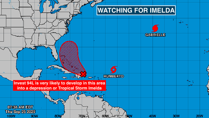
This image provides an overview of the tropical Atlantic Basin on Sept. 25, 2025.
(FOX Weather)
The change from yesterday is that likely-Imelda and Tropical Storm (and eventual Hurricane) Humberto look less likely to get involved with each other in a significant way. Recall that there was concern they might deflect each other in some impossible-to-predict way.
The higher-odds scenario now is that the large upper-level low-pressure system and front that's producing the rain from the Gulf Coast to New England will pick up likely-Imelda and pull it north. If this happens, likely-Imelda and Humberto maintain enough distance from each other that they don’t interact.
In this scenario, after potentially brushing South Florida, Tropical Storm or Hurricane Imelda becomes a threat to the Georgia or Carolina coast early in the week. In addition, the moisture combined with the front could cause dangerous flooding in the Appalachians later next week.
That's not the only potential scenario on the board, however. If the invest gets torn up by the mountains of the Dominican Republic and takes longer to form, the system could stall over the Bahamas or near South Florida.
Also, there's the best-case possibility that after moving north offshore of Florida for a while, likely-Imelda gets scooped by the big upper low and follows likely-Hurricane Humberto out to sea. In this scenario, Bermuda will have to watch both storms.
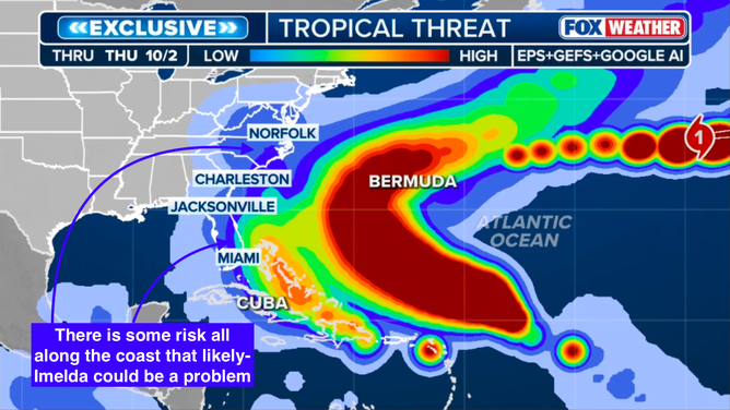
This graphic shows the tropical threats in the Atlantic Basin.
(FOX Weather)
These last two scenarios are certainly possible, but appear to have lower odds than the idea that likely-Imelda will proceed apace to the north.
The bottom line is that everybody from South Florida to the Carolinas and Virginia, including the mountain areas, should stay in touch with the latest developments. And it’s important to remember that forecasts for just-developing systems are always subject to large errors and are likely to change.
Hopefully the forecast will come into better focus tomorrow after eventual-Imelda clears the mountains and is over or near the southeastern Bahamas. But if it looks like the scenario that shows likely-Imelda coming close to South Florida, then making a beeline for the Georgia or Carolina coast, is going to develop, it will happen fairly fast. The current schedule of that scenario has the storm making landfall late Monday or early Tuesday.
Tropical Storm Humberto
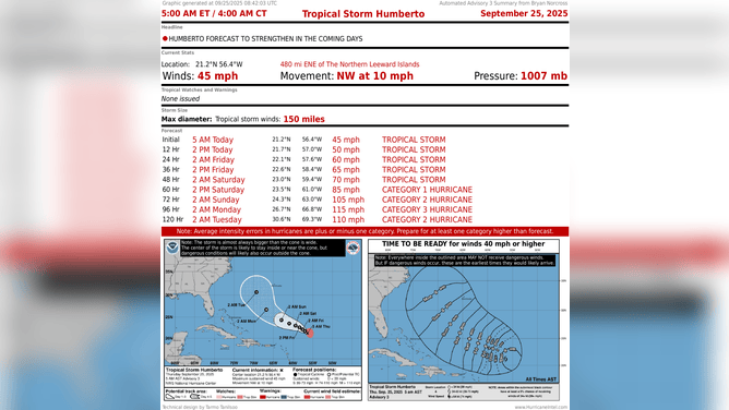
This image provides the latest information on Tropical Storm Humberto.
(FOX Weather)
Humberto is forecast to reach hurricane strength in a couple of days and eventually reach Category 3 strength. Some computer forecasts show it getting even stronger. Residents of Bermuda will have to once again stay informed.
Hurricane Gabrielle
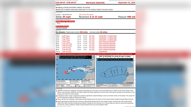
This graphic provides the latest information on Hurricane Gabrielle.
(FOX Weather)
The storm is barreling toward the Azores in the eastern Atlantic. It's very rare for a hurricane to reach those islands, but this one started out strong enough that even with the weakening over cooler water, it's still expected to be a strong storm when it moves through the island chain early tomorrow, their time.
A weaker version of the storm without its tropical characteristics is forecast to impact Portugal over the weekend.