Bryan Norcross: There's finally an area to watch in the eastern Atlantic
A number of the various computer forecast models show the system eventually developing into a tropical storm or a hurricane. As is often the case, according to the computer forecasts, the stronger the storm gets, the more likely it is to turn north into the central Atlantic.

FOX Weather is your Hurricane HQ.
(FOX Weather)
Updated at 9:15 a.m. ET on Thursday, Sept. 11, 2025
The Atlantic, Caribbean and Gulf are still quiet, but a disturbance forecast to move off Africa tomorrow has a chance of eventually developing. The National Hurricane Center is drawing a low-odds development area across a wide swath of the tropical belt.
Recall that "the odds of tropical development" are the chance that the system will become a tropical depression, which only means that the system has an organized circulation. It's a low bar.
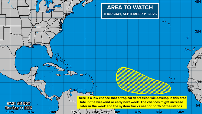
This graphic provides an overview of the tropical Atlantic Basin on Sept. 11, 2025.
(FOX Weather)
A number of the various computer forecast models show the system eventually developing into a tropical storm or a hurricane. As is often the case, according to the computer forecasts, the stronger the storm gets, the more likely it is to turn north into the central Atlantic.
The computer forecasts that do not show the system strengthening, in general, show it moving over or near the Caribbean islands. So it’s definitely a system to watch.
Nothing is going to happen fast. The tropics are still in go-slow mode. On the current schedule, the soonest there would be a threat to the islands, if there ever is, would be the end of next week.
Here’s FOX Weather’s exclusive Tropical Threat output. It analyzes the forecasts of 130 possible tracks from the European model, the U.S. GFS model and the Google DeepMind AI model. The brighter colors represent where there is a greater consensus from the group of models. Research has shown that consensus forecasts are the most accurate. Note that this analysis says nothing about the storm’s potential strength – just its track.
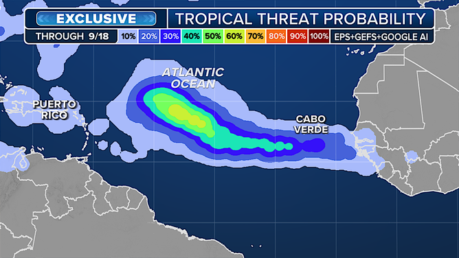
This graphic shows the tropical threat probability in the Atlantic Basin.
(FOX Weather)
We'll also watch to see if this system moistens the tropical belt so that the disturbance behind it has less dust and dry air to deal with. Long-range models indicate that the system coming the week after next is more likely to stay on a southern track.
Having said all that, as always, forecasts for systems that have not even developed are iffy and likely to change.
The extra-strong high-pressure system that has been sprawled across the eastern two-thirds of the Atlantic is forecast to weaken and slowly slide in the general direction of Europe. The strong high appeared to be one of the reasons why the tropics have been hostile to storm development.
The overall weather pattern is now changing. Heat is building in the north, and eventually we’ll see a shift in the pattern over Florida that will decrease the relentless rain.
The odds still favor a busier second half of the hurricane season, with the general atmospheric pattern over the Gulf, Caribbean and Atlantic becoming more supportive of development in the next week or two and then into October.