Bryan Norcross: Tropical Storm Jerry expected to form in Atlantic
The strong dip in the jet stream that's going to keep likely-Jerry well offshore will push a cold front off the Southeast coast. In addition, the sharp jet-stream dip is forecast to spin up a significant low-pressure system – essentially a nor'easter – along the front over or just offshore of the coastline.

FOX Weather is your Hurricane HQ.
(FOX Weather)
Updated at 9:15 a.m. ET on Tuesday, Oct. 7, 2025
The well-formed tropical disturbance tagged Invest 95L is on the cusp of becoming a tropical depression or Tropical Storm Jerry. The National Hurricane Center will likely initiate advisories today.
On the current schedule, likely-Jerry will be in the vicinity of the northeastern Caribbean islands Thursday into Friday. The system looks to be battling dry air and somewhat hostile upper winds at that time, which, if correct, will keep Jerry from rapidly intensifying. Currently, the consensus of the computer forecasts is that Jerry will pass over or near the islands as a tropical storm or perhaps a Category 1 hurricane.
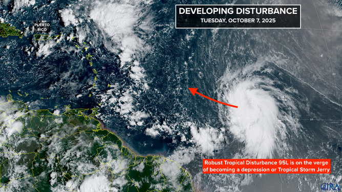
This satellite image shows Invest 95L, which will likely become Tropical Depression Ten or Tropical Storm Jerry, on Oct. 7, 2025.
(FOX Weather)
It's too close to call whether the worst of the storm will directly impact any of the islands beginning on Thursday, so everyone from Puerto Rico around the northeastern Caribbean to Guadeloupe should stay well-informed on the developments with likely-Jerry.
A strong dip in the jet stream over the eastern U.S. will deflect Jerry into the central Atlantic well away from the East Coast and Bermuda. The system will be absorbed by a cold front in the North Atlantic by early next week.
In the southern Gulf
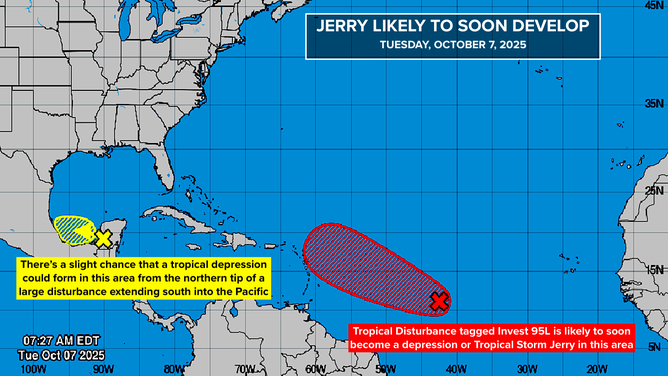
This image provides an overview of the tropical Atlantic Basin on Oct. 7, 2025.
(FOX Weather)
A large disturbance extends from Mexico's Yucatán Peninsula south across South America into the Pacific. As the system heads west, there is a slight chance a low-pressure area could develop in the extreme southern Gulf. It wouldn't be very long-lasting and would likely move into Mexico.
Whether the system develops or not, heavy rain will move from east to west across southern Mexico and Central America. It looks more likely that a storm will develop from the southern part of the disturbance in the Pacific.
The National Hurricane Center has the odds of development in the very low range.
Off the Southeast coast
The strong dip in the jet stream that's going to keep likely-Jerry well offshore will push a cold front off the Southeast coast. In addition, the sharp jet-stream dip is forecast to spin up a significant low-pressure system – essentially a nor'easter – along the front over or just offshore of the coastline.
This won't be a tropical system, at least initially, but it will produce strong onshore winds from North Carolina north across the mid-Atlantic over the weekend. Parts of this coastline were severely damaged from hurricanes Humberto and Imelda, of course. Now there will be additional stress from strong winds and the astronomically high tides this time of year.
The storm is forecast to meander for several days near the East Coast. If it drops south over warm water, it could take on some tropical characteristics. If it stays farther north, however, the water is quite cool, and it's likely to die out as a non-tropical storm.
Whether it ends up being a hybrid-type storm or not, the worst coastal impacts look likely to be in its initial non-tropical phase. Everybody along the Carolina and mid-Atlantic coasts should stay informed as the forecast evolves. Significant coastal flooding is a possibility.