Bryan Norcross: Watching for a threat to the Caribbean next week
There are two non-tropical areas of low pressure — one in the Gulf and the other near the Bahamas. Neither are expected to strengthen significantly or develop into tropical systems.

FOX Weather is your Hurricane HQ.
(FOX Weather)
The broad, disorganized disturbance in the far eastern Atlantic doesn't seem to know what month it is. It’s trying to act like a system in the heart of hurricane season.
There's a strong consensus in the computer forecast models that the system will track toward the northeastern Caribbean late next week. There is no consensus, however, on how strong it will be when it arrives in the vicinity of the northeastern islands Thursday or Friday.
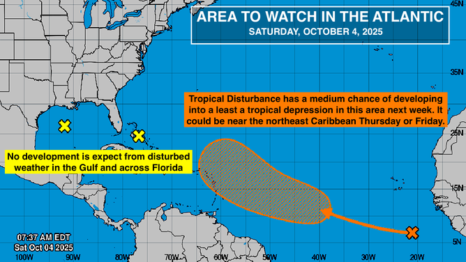
Area to watch in the Atlantic.
(NOAA / FOX Weather)
The National Hurricane Center puts the disturbance’s odds of developing into at least a tropical depression in the medium range. No development is expected for now, but the atmospheric pattern becomes more conducive to organization and strengthening after the weekend.
The various forecasts range from nothing much more than a moisture surge to a hurricane over or close to the islands. As always, definitive forecasts for how disorganized systems are going to develop shouldn't be taken literally. At this point, the best we can do is look at predictions from the variety of credible forecast systems and see where they agree and where they don't.
In the Gulf and Near Florida
There are two non-tropical areas of low pressure — one in the Gulf and the other near the Bahamas. Neither are expected to strengthen significantly or develop into tropical systems.
Both lows are related to the broader weather pattern that is causing strong easterly winds across much of Florida, the Southeast coast, and the northern Gulf. Coastal flooding will continue to be a problem around high tide, especially along the North Florida and Southeast coastline.
Conditions in the surf are dangerous. Pay attention to local instructions.