Bryan Norcross: Stunning and record-breaking Melissa mauls Jamaica
Early indications are that there was damage across Jamaica, but the scale of the destruction in each location remains to be learned.
Bryan Norcross: Hurricane Melissa on track to impact Bermuda after landfalls in Jamaica, Cuba
FOX Weather Hurricane Specialist Bryan Norcross breaks down the latest forecast and impacts for Hurricane Melissa after the catastrophic storm made landfalls in Jamaica and Cuba.
Updated at 9:49 AM E.T. on Wednesday, October 29
The full scope of the disaster in Jamaica is not yet clear, and the impacts from the storm are not finished. Even though Hurricane Melissa is now heading toward the Central and Southeastern Bahamas, the two feet or more of rain that fell across the Jamaican mountains still has to run downhill, meaning the flood threat continues.
Early indications are that there was damage across the country, but the scale of the destruction in each location remains to be learned.
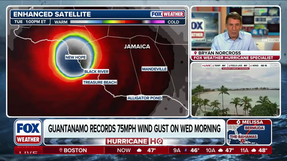
The National Hurricane Center pegged Melissa's wind speed at 185 mph when the storm came ashore in southwestern Jamaica. The town of New Hope was the official landfall point. The strongest winds around Melissa’s eye generated the maximum storm surge around Black River and the nearby resort area called Treasure Beach. Destruction there is likely extensive.
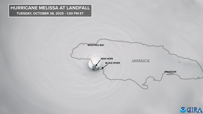
Melissa at landfall.
(CIRA)
The central pressure was measured at 892 millibars. Both the wind and pressure are at the extreme end of the scale. Only one hurricane, Hurricane Allen in 1980, had higher measured winds—190 mph, though it weakened to a Category 3 before making landfall in South Texas.
The cataclysmic Labor Day hurricane of 1935 in the Florida Keys has the same wind and pressure numbers in the official record book – in that case, the pressure was measured, and the winds are estimated. Hurricane Dorian in 2019, which devastated Great Abaco and Grand Bahama Island in the northwest Bahamas, also had top winds measured at 185 mph.
All of the data gathered from the hurricane hunters and every other source will be evaluated by the National Hurricane Center, and a final verdict will be rendered on exactly how strong the winds in Hurricane Melissa likely were. Very often there are small adjustments made to the estimated numbers that were published during the storm.
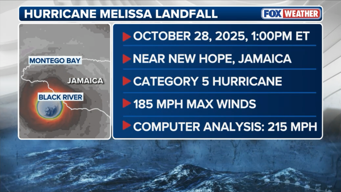
Melissa landfall stats.
(FOX Weather)
Computer estimates put the peak winds at 215 mph, but hurricane hunters didn't find winds that strong during multiple flights back and forth across the circulation. It's an interesting data point, however. The computer estimates are often quite good.
Subjectively, Cat 5 Hurricane Melissa looked like Hurricane Patricia from 2015 that exploded into the most power tropical system on record off the coast of Mexico. Its pressure was lower, however, at 872 mb. The final analysis on Melissa will be interesting.
Cuba, the Bahamas, and Bermuda
Hurricane Melissa made landfall early this morning eastern Cuba with winds estimated at 120 mp. No doubt the situation is quite bad there.
Today, Melissa will pass through the Bahamas. Long Island, Crooked Island, Acklins and nearby islands in the Southeastern Bahamas seem to be in the path. Full hurricane preparations need to be made immediately.
The jet stream dip that is propelling Melissa across the Bahamas and into the Atlantic is also creating a somewhat hostile environment, so the storm is forecast to slowly weaken. But the National Hurricane Center is forecasting Melissa to be at high-end Category 2 or Category 3 strength when it moves through the Bahamas.
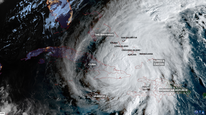
Satellite image of Melissa.
(CIRA)
The Turks and Caicos Islands might be impacted as well, but they would get a glancing blow. A tropical storm warning is in effect there. Nassau and the northeastern Bahamian Islands will not be affected.
Haiti continues to be impacted by Melissa’s outer bands. The situation there is, no doubt, dire.
Amazingly, Bermuda is once again threatened this hurricane season. Category 1 or 2 Melissa will be in the vicinity of the island tomorrow night or early Friday morning. It's too soon to know the level of impact, but a hurricane hit can't be ruled out.
Nothing else appears to be cooking, and this might be it for hurricane season. But weird things can happen, so we'll keep a half an eye on the Caribbean to be sure that there are no surprises.