Bryan Norcross: Forecast for Melissa in Caribbean gaining some clarity
Extreme rainfall is a possibility in the Dominican Republic, Haiti and Jamaica through the weekend. There could be feet of rain in some locations, depending on what part of what islands Melissa's moisture bands impact.

FOX Weather is your Hurricane HQ.
(FOX Weather)
Updated at 9 a.m. ET on Wednesday, Oct. 22, 2025
Tropical Storm Melissa's speed has decreased dramatically, and that trend is forecast to continue. There is reasonably high consensus in the computer forecasts that the storm will creep generally north for the next few days. A weak dip in the jet stream over the Bahamas will try to scoop Melissa out of the Caribbean but will end up just tugging it north.
The storm will likely have to wait for another jet stream dip that reaches far enough south to get the job done. In the meantime, in broad strokes, the computer forecasts show the system drifting west near or south of Jamaica into next week.
There is high consensus that another jet stream dip will come along next week and pull likely Hurricane Melissa north over Jamaica, Haiti and/or Cuba. In fact, there are two dips in the pipeline: a weak one and a very strong one. The question is, which one does the job.
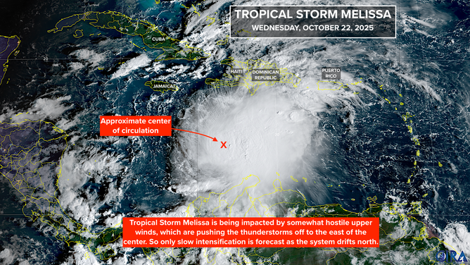
This satellite image shows Tropical Storm Melissa in the Caribbean on Oct. 22, 2025.
(FOX Weather)
If the first dip, which will come by early in the week, ends up being strong enough, Melissa will turn north early – possibly east of Jamaica and over Haiti or extreme eastern Cuba.
On the other hand, if Melissa stays in the Caribbean longer awaiting the second strong dip, it has the significant possibility of intensifying into a very strong hurricane – a Category 4 or 5 can’t be ruled out. When it gets scooped north around Wednesday or Thursday, it could have a direct impact on Jamaica, somewhere in the eastern half of Cuba and the central or southeastern Bahamas – depending on how far west it drifts in the meantime.
In general, the longer it takes for the jet stream to grab the storm, the longer it has over the extremely warm water, the stronger it could be, and the farther west the turn toward the north will occur.
For now, Melissa is fighting hostile upper-level winds and some dry air, which are keeping it from rapidly intensifying. The winds are also tilting the system, so the strongest winds and heaviest rain are east of the center. The atmospheric pattern is forecast to remain somewhat hostile through the weekend, but since the storm is over very warm water, slow, steady strengthening is forecast.
The National Hurricane Center is predicting that Melissa will reach hurricane strength in a few days.
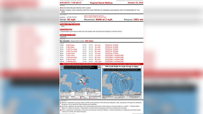
This graphic provides the latest information on Tropical Storm Melissa on Oct. 22, 2025.
(FOX Weather)
Extreme rainfall is a possibility in the Dominican Republic, Haiti and Jamaica through the weekend. There could be feet of rain in some locations, depending on what part of what islands Melissa's moisture bands impact.
Puerto Rico will be on the edge of all this but looks to be impacted by a more or less continuous feed of moisture rotating into Melissa. Watch for flood alerts from the National Weather Service in San Juan.
It's critical that everyone in the northern Caribbean from Puerto Rico to eastern Cuba, including Jamaica, stays up to date on the forecast. The potential for major flash flooding is real, but it’s impossible to say exactly where it will occur. In addition, if Melissa intensifies into a Category 3 or higher hurricane, as many models indicate, the danger increases significantly.
Don’t get stuck on any current prediction. There is a fundamental rule that forecasts for just-developing or slow-moving systems are subject to larger-than-average errors and are likely to change. Melissa is a prototypical slow-mover in its developing stage.