Bryan Norcross: Tropics calming down after Imelda battered Bermuda
Live Hurricane Q&A at 4 p.m. ET on YouTube, Facebook, TikTok, X, Instagram and LinkedIn. Today, my special guest will be Ferran Alet, a Senior Research Scientist at Google DeepMind. The new Google DeepMind computer forecast model has been an amazing and surprising success this hurricane season.

FOX Weather is your Hurricane HQ.
(FOX Weather)
Updated at 10 a.m. ET on Thursday, Oct. 2, 2025
Live Hurricane Q&A at 4 p.m. ET on YouTube, Facebook, TikTok, X, Instagram and LinkedIn. Today, my special guest will be Ferran Alet, a Senior Research Scientist at Google DeepMind. The new Google DeepMind computer forecast model has been an amazing and surprising success this hurricane season. Learn about it and send in your questions about the Google model or weather in general. I’ll see you LIVE this afternoon.

FOX Weather Hurricane Specialist Bryan Norcross' special guest will be Ferran Alet, a Senior Research Scientist at Google DeepMind.
(FOX Weather)
Hurricane Imelda has passed Bermuda after lashing the island overnight. Winds gusted over 90 mph at some of the higher elevations. Bermuda is very hardy, and they seem to have come through fine based on what we’ve seen this morning.
Imelda will soon get scooped up by the polar jet stream and merge with a front – the same mechanism that did in Humberto yesterday. Its remnants will track into the North Atlantic as a strong non-tropical storm.
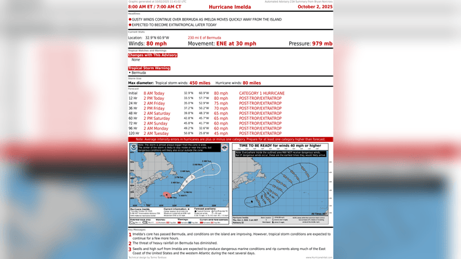
This image shows the latest with Hurricane Imelda on Oct. 2, 2025.
(FOX Weather)
Looking ahead
The National Hurricane Center is highlighting two areas to watch. The odds of something developing in either of them in the next week are in the low range.
In the eastern Atlantic:
Long-range computer forecasts insist that a system will move off Africa in a day or so and track across the tropical Atlantic. It could be in the vicinity of the Caribbean islands at the end of next week. In general, the forecasts that predict a strong storm or a hurricane bend the system north into the open ocean. But it's too early to rely on any forecasts at this point. We'll have to see what shape the system is in when it's over the tropical Atlantic next week.
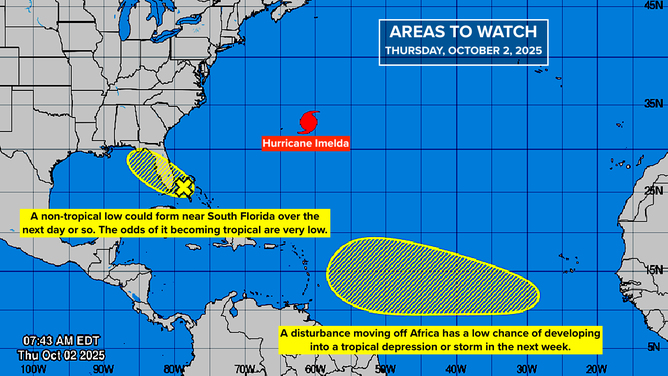
This graphic provides an overview of the tropical Atlantic Basin on Oct. 2, 2025.
(FOX Weather)
Near South Florida:
Some computer forecasts show a non-tropical low-pressure area forming over the Bahamas related to an old front that’s part of the very rainy pattern over the Florida Peninsula. If it forms, it looks like it would drift northwest or north with very low odds of developing.
FOX Weather's exclusive Tropical Threat Analysis also shows a very low chance of development in the extreme southern Gulf of America within the next week. Some of the models show weak low pressure forming there, which often happens in October. More likely, however, a system will develop on the Pacific side of Central America.
You can also see the low-odds areas the NHC is highlighting.
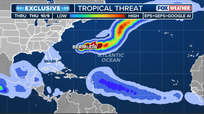
This graphic shows the FOX Weather exclusive Tropical Threat Analysis.
(FOX Weather)
Florida to the Carolinas
The front I just mentioned will bring an extended period of stormy weather to much of Florida. North of the front, strong high pressure is going to continue the onslaught on the beaches that began with the energy from hurricanes Humberto and Imelda.
A band of very strong onshore winds will extend from Central Florida to the Carolinas. Use extreme caution at the beach. Undertow and rip currents will be unusually strong. More beach erosion is likely.