Bryan Norcross: Increasing odds of tropical development in Caribbean this week
One set of predictions calls for the system to strengthen into Tropical Storm or even Hurricane Melissa and quickly move to the north or northeast toward the Dominican Republic, Puerto Rico and/or the nearby islands. Another set of predictions keeps the system weak and calls for it to flounder around in the Caribbean for days – maybe well into next week or beyond.

FOX Weather is your Hurricane HQ.
(FOX Weather)
Updated at 9:45 a.m. ET on Sunday, Oct. 19, 2025
The National Hurricane Center has bumped up the odds that at least a tropical depression will form in the Caribbean this week. They now have chances in the high-medium range, which is in line with the consensus of the computer forecasts.
The tropical disturbance we've been following on its trek from Africa will cross the southeastern Caribbean islands – the Windward Islands – today and into tomorrow. The outer bands of the developing system extend about as far north as Guadeloupe and south through the Windward Islands to Trinidad.
Winds have been measured by satellite gusting to near tropical storm strength, and there's plenty of moisture to produce heavy downpours. The system doesn't have a full, closed circulation, so it's not designated a depression or a tropical storm. But the impact on the islands will be the same.
The disturbance has been speeding along at 20-25 mph. By Wednesday, it will be in the central Caribbean, and the steering currents are forecast to collapse. This is where the various computer forecasts diverge.
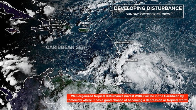
This satellite image shows Invest 98L approaching the Caribbean on Oct. 19, 2025.
(FOX Weather)
One set of predictions calls for the system to strengthen into Tropical Storm or even Hurricane Melissa and quickly move to the north or northeast toward the Dominican Republic, Puerto Rico and/or the nearby islands. Another set of predictions keeps the system weak and calls for it to flounder around in the Caribbean for days – maybe well into next week or beyond.
The various computer models give us odds that each of the scenarios might play out. In round numbers, the likelihood of a strong storm immediately turning to the north is about 20%, and 40-50% that a weak but organized storm will hang in the Caribbean at least into next week. There's also a decent chance that it won't develop at all.
There is also the complication that a second low-pressure system might develop in the extreme southern Gulf of Mexico. Some of the computer forecasts show that happening. It appears that potential development is from the combined effect of a separate, weak tropical disturbance and the typical broad area of low pressure over Central America called the Central American Gyre.
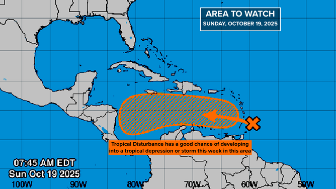
This graphic shows information on Invest 98L on Oct. 19, 2025.
(NOAA)
How these two low-pressure areas will influence each other if they both develop is an open question.
As far ahead as we can reasonably forecast – about 10 days – there is no sign of a threat to the mainland U.S. But residents of Puerto Rico and the surrounding islands should plan to stay informed this week until we see what happens midweek. If the system quickly develops, its move north could occur almost immediately.
A strong dip in the jet stream is forecast to be over the East Coast of the U.S. on Wednesday and Thursday. If the system strengthens, the jet-stream dip will have a chance to scoop up the likely tropical storm and pull it north. If development is slow, however, the scoop will pass by, and the system, whatever form it’s in, will likely loll around in the Caribbean for several days, at least.
For now, stay informed.
20 years ago today
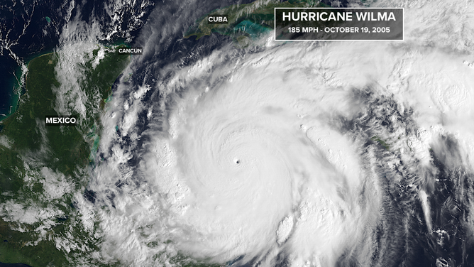
This satellite image shows Hurricane Wilma on Oct. 19, 2005.
(FOX Weather)
On Oct. 19, 2005, Hurricane Hunters measured the lowest pressure ever recorded in an Atlantic hurricane – 882 millibars. Hurricane Wilma had exploded in 24 hours from a Category 1 to a 185-mph Category 5. The eye was less than 2.5 miles across. Here is the incredible satellite image from that day.
Wilma went on to maul Cancún and Cozumel on Mexico’s Yucatán Peninsula before turning toward South Florida. The winds only reached Category 1 strength in Miami-Dade County and Category 2 in part of Broward and Palm Beach counties, but Hurricane Wilma was the third-most-expensive hurricane on record at that time. Only Katrina and Andrew cost more.