Bryan Norcross: Persistent hostile winds bring forecast numbers down a notch
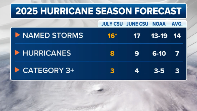
The new forecast calls for a total of 16 named storms this hurricane season. Eight of them would become hurricanes, and 3 of those would strengthen to Category 3 or above if the forecast is correct.
Update on hurricane season outlook from Colorado State University
FOX Weather Hurricane Specialist Bryan Norcross covers the latest hurricane season outlook from Colorado State University. The new projection shows a slight decrease in the hurricane forecast. Norcross breaks it all down.
The team at Colorado State University, led by Dr. Phil Klotzbach, is out with their updated seasonal prediction. It's based on conditions across the tropics that were observed on June 1, with an adjustment for the predicted atmospheric pattern for the rest of July.
The new forecast calls for a total of 16 named storms this hurricane season. Eight of them would become hurricanes, and 3 of those would strengthen to Category 3 or above if the forecast is correct.
All of those numbers are down one from their April and June predictions. The asterisk is to indicate that the predicted 16 named storms include the three tropical storms that have already formed and died out—Andrea, Barry, and Chantal. So, according to the prediction, 13 more named storms will form this season.
Updated hurricane season forecast from CSU.
(FOX Weather)
The average of the various forecast schemes deployed by the CSU team predicts about 19 named storms. But Dr. Klotzbach and the team trimmed that number because of the current and forecast hostile wind regime across the Caribbean.
The bottom line is that an average to slightly above-normal hurricane season is predicted, with the huge caveat that massively impactful storms can and do occur in so-called average seasons.
Looking Ahead
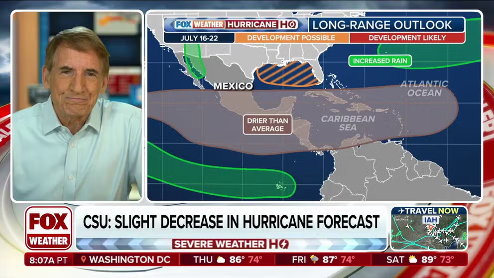
Dry air, including Saharan dust, hostile upper winds, high air pressure, and relatively cool water temperatures are keeping the tropics calm for now. Long-range computer forecast models, including the new Google experimental AI model, indicate the slight possibility that something could develop in the northern Gulf about a week from now—although the timing in the various predictions varies.
That potential development seems to have a non-tropical component, similar to the triggers for the first 3 storms this season, perhaps combined with a weak disturbance that pushes through the hostile Atlantic conditions and into the Gulf.
NOAA issues these long-range tropical prediction maps. Notice they have a hatched area in the northern Gulf for the end of next week into the following week that shows less than a 20% chance of something developing. The long-range computer models are showing less than a 10% chance of an organized system developing. There is no reason for concern.
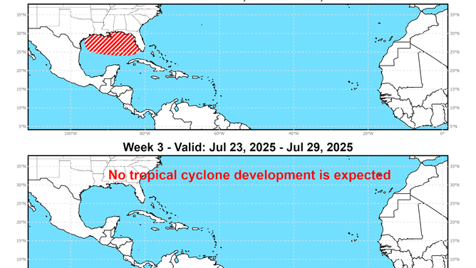
A look at the Global Tropics Hazards Outlook for July 16-July 22, 2025
(NOAA)
The large-scale atmospheric pulse called the MJO enhances tropical activity when it passes by. The MJO, or Madden-Julian Oscillation, was identified by two atmospheric scientists, Madden and Julian, in the early 1970s.
The MJO pulse has not been a factor in the Atlantic this year, but there is some indication that it will move into the Gulf, Caribbean, and Atlantic toward the end of this month or early in August, creating a more conducive environment for storms to develop.
Again, we are looking too far ahead to have any certainty, but the MJO is a factor we watch.
For now, we rest. And prepare, of course.