Bryan Norcross: Weak disturbance tracking across northern Gulf this week
The non-tropical disturbance is currently centered near northeast Florida and is related to a dying front that stretches across the Southeast and offshore of the Carolinas.

FOX Weather is your Hurricane HQ.
(FOX Weather)
Updated at 9 a.m. ET on Wednesday, July 23, 2025
The National Hurricane Center has picked up on the weak disturbance we've been following. They are giving it a very low chance of developing. The non-tropical disturbance is currently centered near northeast Florida and is related to a dying front that stretches across the Southeast and offshore of the Carolinas. There is no consolidated area of low pressure right now, but as the front dies out, a somewhat more organized system is forecast to develop over the northern Gulf.
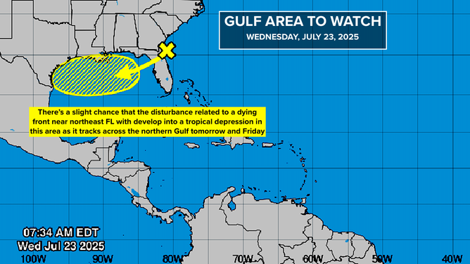
The National Hurricane Center has picked up on the weak disturbance we've been following.
(NOAA)
The circulation around the heat dome high-pressure system to the north will propel the developing disturbance across the northern Gulf toward Texas. There is no indication in the various computer forecasts that a significant storm will develop, but to be on the safe side, the NHC is mentioning it. Their low odds only pertain to whether the system could attain tropical depression status, which only means that it forms an organized circulation – a very low bar.
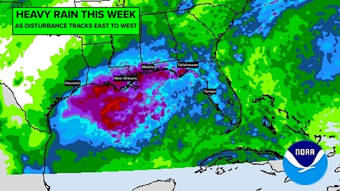
Whether it becomes a depression or not, the main impact from all this will be enhanced tropical rain for Florida today and for the northern Gulf Coast across to Texas tomorrow and Friday.
The circulation around the heat dome high-pressure system to the north will propel the developing disturbance across the northern Gulf toward Texas.
(NOAA)
If you feel like you've heard this story before, you're right. A couple of weeks ago, a similar disturbance on a similar track was designated Invest #93L. It never did develop, but it brought very heavy rain to some areas in North Florida west to Louisiana. In fact, the remnants of #93L looped all the way around the heat dome high-pressure system to the north and became a seed for the development of the current disturbance.
The rainfall projections for this system are not as heavy as they were for #93L. Still, the system is surrounded by a thick blob of tropical moisture, so intense downpours are likely. Stay aware of any potential local flood alerts from the National Weather Service.
Otherwise, nothing looks to be cooking in the tropics for the rest of the month.