Bryan Norcross: Fringy disturbances to keep an eye on
On the current schedule, a tropical disturbance will be in the vicinity of the Caribbean islands Wednesday or Thursday. The atmospheric pattern near and over the islands is forecast to be quite hostile, so even if it momentarily develops over the open ocean, it looks likely to be a weak system, probably just a moisture surge, when it passes into the Caribbean Sea.

FOX Weather is your Hurricane HQ.
(FOX Weather)
Updated at 9 a.m. ET on Sunday, July 20, 2025
The tropical disturbance that came off Africa last week is more than halfway to the Caribbean. It's not showing any signs of organization. The National Hurricane Center has the chances in the low category that it will ever meet the requirements to be called a tropical depression.
It will be traveling over warm water in a somewhat conducive atmospheric environment, except that it's brushing up against extremely dry air. It's still possible that it could find a small pocket of conditions conducive to development over the next day or two, but it's unlikely.
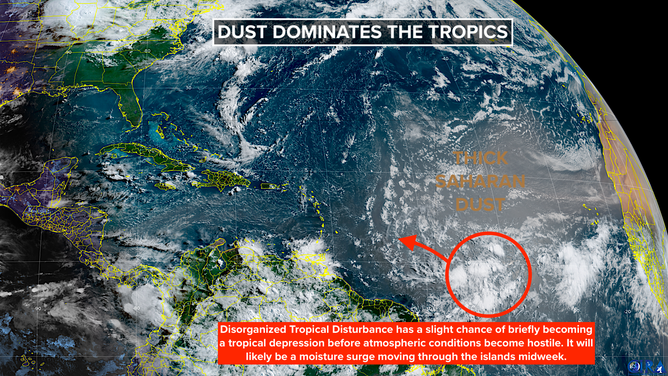
A disorganized tropical disturbance has a slight chance of briefly becoming a tropical depression before atmospheric conditions become hostile. It will likely be a moisture surge moving through the Caribbean islands midweek.
(Bryan Norcross / NOAA)
On the current schedule, it will be in the vicinity of the Caribbean islands Wednesday or Thursday. The atmospheric pattern near and over the islands is forecast to be quite hostile, so even if it momentarily develops over the open ocean, it looks likely to be a weak system, probably just a moisture surge, when it passes into the Caribbean Sea.
There's no indication that this system would have time or the atmospheric support to become terribly strong.
It's been unusually dry across the tropics, so some rain over the islands would be beneficial.
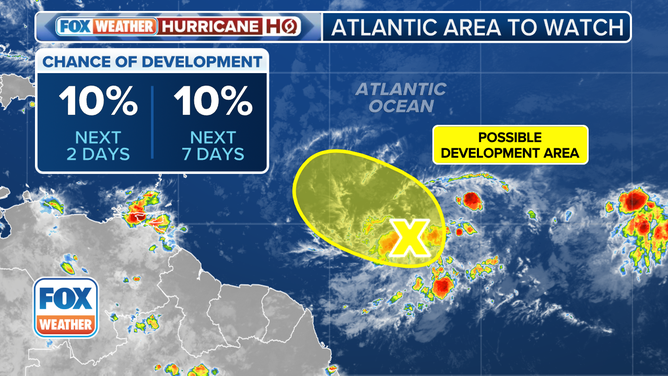
The outlook for a tropical disturbance in the central tropical Atlantic Ocean.
(FOX Weather)
There is nothing imminent elsewhere in the tropics, but another rain-making front will straddle North Florida from the northern Gulf to off the Southeast coast later this week.
This is a similar scenario to what we went through last week that generated the tropical disturbance in the Gulf. In fact, a case can be made that a piece of last week's disturbance will be part of this one.
Like last week, a strong high-pressure system to the north – this one will be the heat-dome high producing extremely hot weather across parts of the mid-South and Midwest – will provide the steering for any disturbed weather that develops along the old front. The flow around that high will push the moisture and any disturbance that might form from east to west across Florida and into the northern Gulf.
There's nothing to look at now, and there's no indication that an organized system will develop, but more rounds of heavy rain are possible in Florida and along the Gulf Coast.
Broadly speaking, the tropics are still shut down. But that doesn't mean low-end systems won't try to spin up on the fringes of the big high-pressure system covering the Atlantic, the Caribbean and most of the Gulf. We'll keep half an eye on things, but there's nothing of concern.