Bryan Norcross: Gulf Coast faces flood threat from Invest 93L which could still develop
The consensus of the various computer forecasts is that its best opportunity to organize into a tropical depression will be tonight or tomorrow very close to the Louisiana or Mississippi coast.

FOX Weather is your Hurricane HQ.
(FOX Weather)
Updated at 8:30 a.m. ET on Wednesday, July 16, 2025
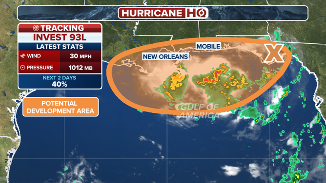
The disorganized disturbance we've tracked across North Florida is now trying to reform in the northeastern Gulf. The National Hurricane Center officially tagged the system Invest 93L. Hostile upper-level winds are not allowing it to develop for now. But it looks likely that the broad and sloppy disturbance will track in the direction of Louisiana, or perhaps reform over or near the mouth of the Mississippi River in extreme southeastern Louisiana by late today.
The consensus of the various computer forecasts is that its best opportunity to organize into a tropical depression will be tonight or tomorrow very close to the Louisiana or Mississippi coast.
The outlook for an area of possible development moving into the Gulf this week.
(FOX Weather)
Whether it ever achieves tropical depression status or not, the threat is going to be heavy rain along the northern Gulf Coast. Because the system is strung out and reforming, the rain extends from the Florida Panhandle to Louisiana. The heaviest rainfall has been offshore but is expected to affect the entire north-central Gulf Coast plus the Florida Panhandle.
There is a pocket of upper winds that are somewhat conducive to development over the northern Gulf. If the system can take full advantage of that, it's not impossible that Tropical Storm Dexter could spin up somewhere near the mouth of the Mississippi, although the top end on any development appears low.
Be on the lookout for flood alerts from the local National Weather Service offices for the next few days. The system, whatever form it's in, looks likely to linger near southeastern Louisiana at least into Friday.
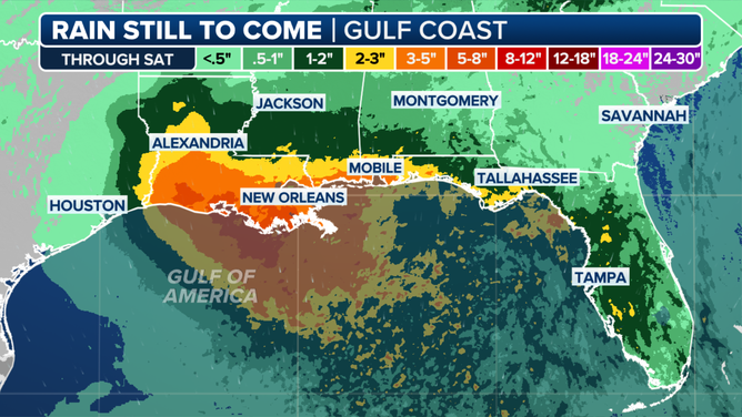
Gulf Coast rain threat.
(FOX Weather)
Circulation on the backside of the disturbance will pull tropical moisture over Florida, so some heavy rainstorms are still possible. But they will feel more like typical early-summer downpours than something related to a tropical system.
As what's left of the system edges toward Texas on Friday, a pocket of heavy rain will go with it.
Otherwise, no tropical activity is expected for the next week. And there's a good chance the rest of July will be calm, though a fringe event like this disturbance or Chantal is always possible.