Bryan Norcross: Disturbance continues to drench Florida, could develop in Gulf
Heavy rain with local flooding and frequent lightning is likely Tuesday over the Florida Peninsula once again. Stay aware of flood alerts that are issued by the National Weather Service.

FOX Weather is your Hurricane HQ.
(FOX Weather)
Updated at 9 a.m. ET, Tuesday, July 15, 2025
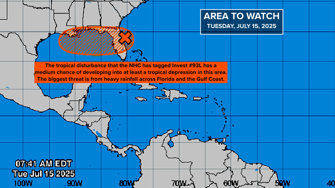
The tropical disturbance that created bands of torrential tropical downpours on Monday will move across the Florida Peninsula on Tuesday. Heavy rain with local flooding and frequent lightning is likely over the Florida Peninsula once again. Stay aware of flood alerts that are issued by the National Weather Service.
The disturbance is showing some signs of a circulation, but it's disorganized and broad. The air is already extremely humid over Florida, and the disturbance is bringing more tropical moisture with it. The moisture combined with the heating of the day will likely produce intense, slow-moving thunderstorms – the type that can cause local flooding.
The system is forecast to move into the Gulf tomorrow where it might have a chance to organize over the very warm water. The National Hurricane Center has the odds of it becoming at least a tropical depression in the medium range. According to the computer forecasts, if it does develop an organized circulation, it's most likely to do it late tomorrow or early Thursday when it is approaching Louisiana.
A disorganized disturbance off the east coast of Florida is forecast to bring heavy rain to the Florida Peninsula into Wednesday.
(NOAA)
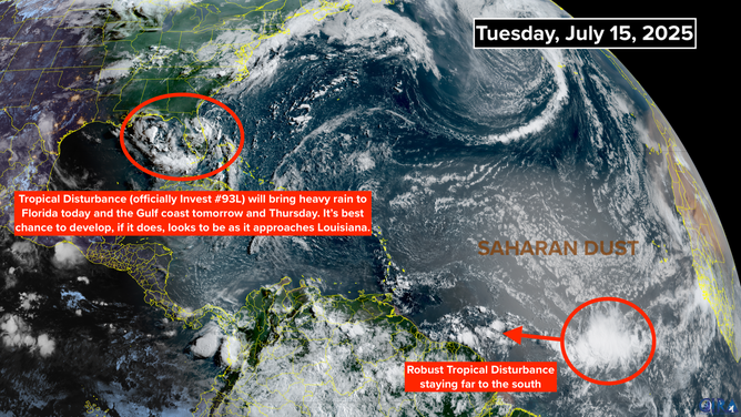
Interestingly, most of the computer forecasts show a fairly weak system in the vicinity of southeastern Louisiana by Thursday. But the new Google experimental AI model and some others indicate that the system could quickly spin up into a reasonably strong storm. The name would be Tropical Storm Dexter.
The idea is that the model gives us a reasonable range of possibilities, so we know what to ready for. It's not a forecast as much as it's a heads up. So the strength of the system is an open question, but the very heavy rain over the northern Gulf coast from the Florida Panhandle to Louisiana looks likely. Be ready for flood watches to be issued for areas along the coast.
An area of disturbed weather offshore of the Southeast coast is going to turn into a problem for the Florida Peninsula this week
(NOAA)
As always, forecasts for disorganized or just developing systems are subject to greater errors and often have to be adjusted when and if a consolidated circulation develops.
Elsewhere in the Atlantic, a robust tropical disturbance is midway between Africa and the Caribbean. It’s on a southern track and will likely bring a noticeable moisture surge to the southeastern Caribbean islands and Venezuela late in the week. The tropical ocean is still blanketed with dry air and Saharan dust, so development is not expected. But it’s a reminder that the African disturbance-producing system is working.
The ocean water temperatures are warming between the Caribbean and Africa, so in a couple of weeks, we'll start looking in that direction for possible development.