Bryan Norcross: No threats in the short term, but watching for developments next week
In preparation for the peak of hurricane season, we’re doing another Hurricane HQ&A live on social media this afternoon at 1:30 p.m. ET. This week we’re going to test streaming to 10 social media platforms simultaneously – multiple channels on Facebook, YouTube, TikTok, LinkedIn, X and Instagram.

FOX Weather is your Hurricane HQ.
(FOX Weather)
Updated at 9 a.m. ET on Thursday, Aug. 7, 2025
In preparation for the peak of hurricane season, we’re doing another Hurricane HQ&A live on social media this afternoon at 1:30 p.m. ET. This week we’re going to test streaming to 10 social media platforms simultaneously – multiple channels on Facebook, YouTube, TikTok, LinkedIn, X and Instagram.
I’ll answer your questions as well, of course, but we’d also like to hear from you to know how the system is working.
We want to be ready in case we have a significant threat this season.

FOX Weather Hurricane Specialist Bryan Norcross will be hosting Hurricane HQ Q&A on Aug. 7, 2025.
(FOX Weather)
Across the Atlantic
Two very different systems are thinking about developing – one near the Southeast coast and the other far out in the tropical Atlantic. Meanwhile, Tropical Storm Dexter is in its last day as a tropical storm. It has almost fully transitioned to a non-tropical North Atlantic low-pressure system.
The system’s winds are forecast to reach hurricane strength, but it won’t be termed an official hurricane since its structure will be like a nor’easter.
System offshore of the Southeast
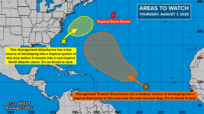
This graphic provides an overview of the tropical Atlantic Basin on Aug. 7, 2025.
(FOX Weather)
A weak circulation has formed on the northern end of an elongated area of disturbed weather well offshore of Florida and the Southeast coast. The circulation is forecast to move north, passing offshore of Cape Hatteras, North Carolina, in a couple of days. The National Hurricane Center is giving the system a low chance of becoming a tropical depression or tropical storm because it's going to run out of time.
Computer forecast models predict that the system will intensify, but as a non-tropical storm like the new version of Dexter. It will only get a name if it still has some tropical characteristics when it organizes, and the window of time when that could happen appears to be short.
If the system passes offshore of eastern North Carolina as currently forecast, it should have minimal effect. In fact, it would draw dry air across the Carolinas, diminishing the chances of rain this weekend.
The bottom half of the system will break off and continue across the Florida Peninsula, increasing atmospheric moisture and the chances of tropical downpours. Late in the weekend, the system heads into the Gulf.
Computer forecasts have shown a slight chance a low-pressure system might develop in the Gulf, but nothing significant is expected. The main effect will be another surge of tropical moisture over the Southeast lasting into next week, once again increasing the chance of thunderstorms.
Activity in the tropical Atlantic
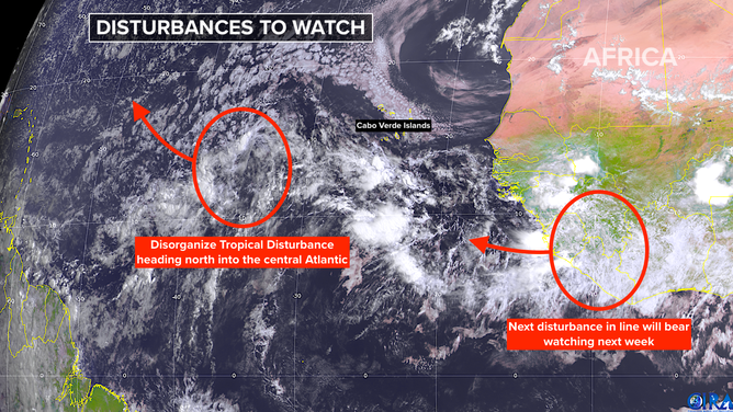
This satellite image provides an overview of the tropical Atlantic basin on Aug. 7, 2025.
(FOX Weather)
The tropical disturbance we've been following is slowly beginning its move to the north. The National Hurricane Center has tagged it Invest 96L – meaning they are running their array of computer models specifically designed for tropical systems.
There is high confidence this system will not impact land. The National Hurricane Center gives it a medium chance of developing into a tropical depression or tropical storm. It will be fighting dry Saharan dust and, at times, hostile upper winds as it tracks into the central Atlantic. In any case, it's no threat.
Looking ahead
Another tropical disturbance is about to move off Africa. Blocking high pressure is forecast to keep this one from turning north so quickly, so it will head in the general direction of the Caribbean for a good part of next week.
Some long-range computer forecasts indicate that this system could be a threat to land around next weekend and into the following week. Others show it turning north well east of the U.S. Obviously, 10-plus days out is well past the time that we have any confidence in the forecasts, but it is likely an indication that the overall weather pattern over the Atlantic is increasingly conducive for tropical storms and hurricanes to develop.
For now, don't focus on the long-range forecasts. The odds of any particular outcome actually happening are extremely low, so it’s not worth thinking about. Let's see what state the system is in when we start next week.
Forecasts for disorganized systems or systems that haven’t yet organized are subject to large errors and always jump around. There is nothing for the computer models to lock on to, so there’s no clean starting point from which to make a forecast. Ignore social media posts and plan a nice weekend.