Bryan Norcross: CSU out with new forecast while tropical potential development areas expand
The forecasters acknowledge that this prediction comes with more uncertainty than normal because of conflicting signals across the tropics.

Bryan Norcross: No change in hurricane season outlook; Southeast on alert for area to watch
FOX Weather Hurricane Specialist Bryan Norcross breaks down the latest hurricane season outlook from Colorado State University and the area to watch off the Southeast Coast.
Updated at 11 a.m. ET on Wednesday, Aug. 6, 2025
The forecasting team at Colorado State University led by Dr. Phil Klotzbach has issued their final forecast of the year. They didn't make any changes from the July prediction. They're staying with 16 named storms, eight of which develop into hurricanes, and three of those become Category 3 or higher.
The forecasters acknowledge that this prediction comes with more uncertainty than normal because of conflicting signals across the tropics. On one hand, the Atlantic and Pacific water temperatures are in ranges that are somewhat supportive of tropical development. On the other, the upper-level winds over the Caribbean through June and July have been hostile, and that's normally a sign of less storm development across the Atlantic.
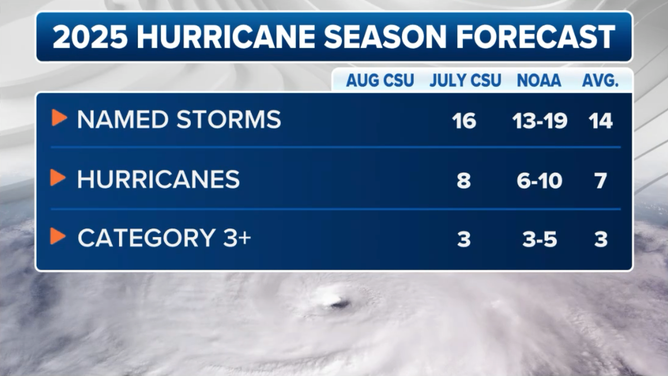
This graphic shows the latest predictions for the 2025 Atlantic hurricane season from Colorado State University.
(FOX Weather)
The net result is the steady-state forecast – a slightly above-average season.
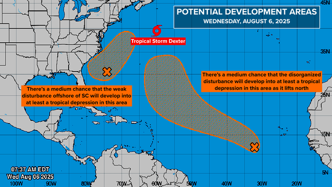
Across the tropics today, atmospheric conditions continue to be somewhat hostile, so nothing is expected to develop quickly. But the National Hurricane Center is drawing potential development areas near the Southeast coast and in the middle of the ocean.
There is a decent chance that both of these systems will eventually develop into at least a depression, if not a named storm. But there are conflicting signals on when it will happen, so the potential development areas have been expanded.
Offshore of the Carolinas
This graphic shows tropical activity in the Atlantic basin.
(FOX Weather)
The weather pattern is stuck in a rut over the Southeast. Now, odds have increased slightly that another storm will develop offshore of the Carolinas triggered by low pressure loosely associated with the old front that's been hanging around. The National Hurricane Center gives the system a medium chance of developing into at least a tropical depression.
Current computer forecasts show the system slowly developing tomorrow and then drifting past Cape Hatteras and out to sea over the weekend. If the system tracks over the Gulf Stream, there's a good chance it will strengthen into Tropical Storm Erin. If, however, it interacts with land, it could stay disorganized.
The exact track has a lot to do with how much rain falls over the Carolinas. A track along the coast could produce flooding rains. A track offshore, which now looks more likely, would reduce the amount of rain over eastern North Carolina.
Since the system hasn't developed yet, as always, the forecasts are subject to larger than normal errors and are subject to change.
At the same time that potential-eventual-Erin is drifting along or near the Carolina coast, a related moisture-laden mid-level disturbance will move across Florida and into the Gulf. This will increase the likelihood of tropical downpours across the Florida Peninsula. Eventually, the system is forecast to track into the northern Gulf, bringing another slug of moisture into the Southeast early next week.
Some of the computer forecast models suggest that a weak low-pressure system could form over the warm Gulf waters. That's still a possibility, but the odds are very low. In any case, it wouldn't be significant. The extra moisture and the heavy rainfall are the main issues.
Over the tropical Atlantic
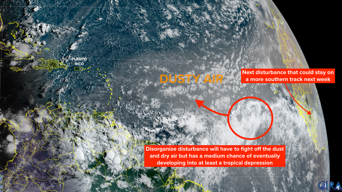
This satellite image shows the tropical Atlantic basin on Aug. 6, 2025.
(FOX Weather)
The disturbance we've been following is slowly tracking across the tropical Atlantic just south of a plume of Saharan dust. A second disturbance on its heels will cross the African coast in the next couple of days.
The first disturbance triggered the NHC's large potential development area, showing medium odds of the system becoming a tropical depression somewhere in that orange zone. By tomorrow, the consensus of the various computer forecasts is that it will begin its move north through the dust and dry air. By the weekend, there's a decent chance it will find a pocket well north in the Atlantic that's conducive enough to development that the system will evolve into a tropical depression or perhaps a tropical storm.
If the system near the Southeast uses Erin, this one would be Fernand.
The forecasts that had been showing the possibility of the system staying south and heading west on a threatening path have changed their mind. The consensus is this system will head north and not affect land. But of course, we will keep an eye on it to be sure.
The trailing disturbance looks to take a southern route. There's no indication of any rapid development, and the weather pattern does not look especially conducive to the system strengthening quickly next week, but some credible long-range projections indicate the possibility of an eventual threat.
It will bear watching, of course, as we head into the middle of the month when statistics say the odds of storm development start to increase quickly.