Bryan Norcross: Remembering Hurricane Katrina in South Florida as tropics quiet down
Tonight at 8:30 PM ET on FOX Weather we’re going to air the first part of a series looking back at Katrina, and where things stand 20 years on. It’s called Katrina’s Wrath: 20 Years Later.

FOX Weather is your Hurricane HQ
(FOX Weather)
Updated at 9:30 a.m. ET on Aug. 25, 2025.
August 25 was a Thursday in 2005. Just two days before, new Tropical Depression Twelve had formed over the Bahamas. From the get-go, it was predicted to track towards South Florida. The forecast turned out to be excellent, although the storm strengthened a little more than expected.
Hurricane Katrina made its first landfall near Hollywood, Florida – just north of the Miami-Dade/Broward County line – at about 6:00 PM ET 20 years ago today.
The storm was lopsided, tilted by somewhat hostile upper winds. The strongest winds and heaviest rain were on the left side of the system, so Miami-Dade County got the worst of it, including flooding from torrential rain in Miami's southern suburbs.
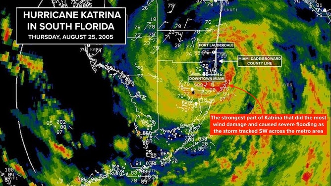
This radar image shows Hurricane Katrinia over South Florida on Aug. 25, 2005.
(FOX Weather)
The storm leaned hard left near landfall, and ended up tracking directly over the new National Hurricane Center in southwest Miami-Dade, which had been built as a fortress after Hurricane Andrew.
After it crossed the Florida peninsula, we knew Katrina was likely to turn toward the northern Gulf Coast, but like before Hurricane Andrew, we could not conceive of what would happen Monday morning, August 29, 2005 – just four days later.
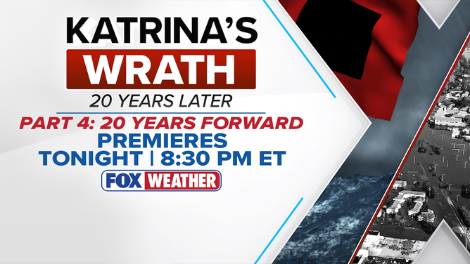
Watch Katrina's Wrath: 20 Years Later premiering Aug. 25, 2025 on FOX Weather.
(FOX Weather)
Tonight at 8:30 PM ET on FOX Weather we’re going to air the first part of a series looking back at Katrina, and where things stand 20 years on. It’s called Katrina’s Wrath: 20 Years Later.
We visit the neighborhoods in New Orleans that were devastated and talk to the people who were there. The stories are compelling, and the lessons are important.
FOX Weather is available for free on your TV, tablet, or phone. Go to FoxWeather.tv to learn how to watch us.
The series will air every evening this week at 8:30 PM ET, with all four parts airing together Friday evening.
In the tropics today
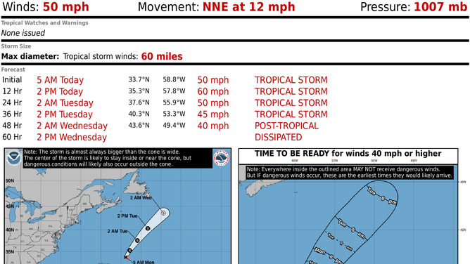
This graphic shows information on Tropical Storm Fernand.
(FOX Weather)
In the Atlantic, Tropical Storm Fernand passed well east of Bermuda and is arcing out to sea. It’s forecast to die out in a couple of days.
In the Caribbean, the tropical disturbance we've been following (Invest 99L) is bringing some gusty winds and tropical downpours to the eastern Caribbean Islands. But it never could organize.
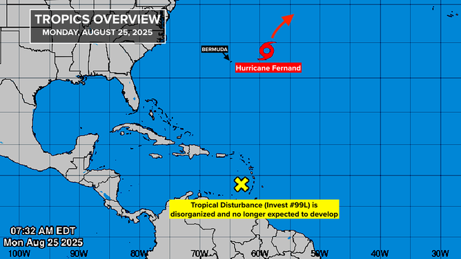
This graphic provides an overview of the tropical Atlantic basin on Aug. 25, 2025.
(FOX Weather)
Atmospheric conditions in the Caribbean are hostile, and the system is likely to degenerate in a day or two.
What's left of the disturbance will most likely head into Central America at the end of the week.
The next week or two in the tropics
Nothing obvious is cooking. The overall atmospheric pattern is somewhat hostile to development, but that doesn't completely preclude something spinning up. We'll watch an unusually strong cold front that will settle over Florida this week. Fronts can sometimes be triggers for tropical development, as we've seen a number of times this year.
For now, let's assume that Mother Nature is taking a snooze.