Bryan Norcross: Tropical Storm Fernand will likely develop soon in the Atlantic
The National Hurricane Center has the odds of development of Invest 90L tracking in the general direction of Bermuda at 100%. Development in this case means the system attaining an organized circulation and being designated a tropical depression.

Tropical Storm Fernand may form later Saturday
Invest 90L now has a "near 100% certainty" of becoming a tropical cyclone -- perhaps Tropical Storm Fernand -- as soon as Saturday, the NHC said.
Erin is no longer officially a hurricane. The system has morphed into a powerful non-tropical North Atlantic storm and is heading in the direction of the United Kingdom and northern Europe. Erin's energy is still agitating the waters along the East Coast of the US, however.
The weather post-Erin will be spectacular along much of the East Coast, but be extra careful if you plan to go in the ocean. Follow local instructions. It's hard to imagine how much energy a giant hurricane like Erin puts into the vastness of the Atlantic. It takes time for the strong currents to dissipate.
Watching for Tropical Development
There are two invests on the board, meaning there are two systems that the National Hurricane Center is investigating with tropical storm-specific models: Invest #90L and Invest #99L.
Yes, the numbering system is crazy. Invests are numbered from 90 to 99, and then the numbers revert to 90. It's a leftover system from before the Internet. It was never designed to be public. The "L" refers to the Atlantic because "A" is used for storms in the Arabian Sea.
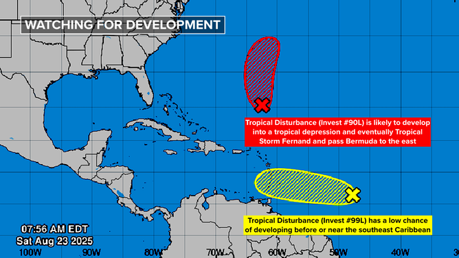
Atlantic tropics overview.
(National Hurricane Center / NOAA)
Invest 90L
The National Hurricane Center has the odds of development of the system tracking in the general direction of Bermuda at 100%. Development in this case means the system attaining an organized circulation and being designated a tropical depression. Computer forecasts indicate it's likely that winds in the circulation reach 40 mph and the system is named Tropical Storm Fernand. There’s some chance it will become a hurricane.
The strong consensus of the computer forecasts is that the system will track east of Bermuda late Sunday or early Monday well offshore of the United States. They'll watch it in Bermuda just to be sure.
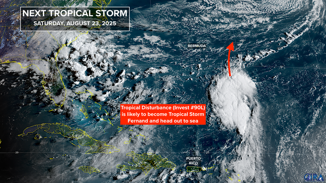
Satellite image of Invest 90L in the Atlantic.
(Bryan Norcross / NOAA)
Invest #99L
This system tracking across the main tropical belt has almost had a circulation for a couple of days, but it hasn't been able to fully organize.
The National Hurricane Center now has #99L's odds of developing into at least a tropical depression in the low range. Conditions ahead are only marginal for development.
The system will likely come through the Windward Islands (the southern Caribbean islands) Sunday and Monday. Residents there should keep an eye on it, but there's no sign that it would be a strong storm, even if it were able to develop. Most likely it will be a gusty moisture surge.
If this system suddenly spun up, conceivably it could beat #90L to Fernand. The "G" name is Gabrielle.
Quiet Times Ahead
Long-range computer forecasts show that the tropics will take a snooze once these two systems are off the board. That should take us into September.
An unusually strong fall cold front will be pushing off the East Coast early next week and draping itself across the Florida Peninsula. As we have seen a few times this year, fronts that stall over the very warm Gulf and Gulf Stream can spin up into tropical systems. We'll keep an eye out for that in about a week.