Bryan Norcross: Hurricane Erin's impacts on US East Coast will increase through the day
The atmosphere ahead of Erin looks to be reasonably conducive for intensification, so the National Hurricane Center is forecasting the top winds to increase slightly to the top end of the Category 2 range.

Bryan Norcross: Hurricane Erin intensifying, could become major hurricane once again
The latest advisory from the National Hurricane Center shows Hurricane Erin is once again starting to intensify and could become a major hurricane as it churns in the waters off the U.S. East Coast. FOX Weather Hurricane Specialist Bryan Norcross takes a deep dive into the latest forecast on Aug. 20, 2025.
Updated at 9:45 a.m. ET on Thursday, Aug. 20, 2025
Even though Hurricane Erin's top winds are not as intense as they once were, the storm has grown in size, so its impacts will spread over a wider area.
The atmosphere ahead of Erin looks to be reasonably conducive for intensification, so the National Hurricane Center is forecasting the top winds to increase slightly to the top end of the Category 2 range. The central pressure is already dropping, so the intensification process seems to already be underway. Although in a giant storm, the process is slow because there is so much air to get moving.
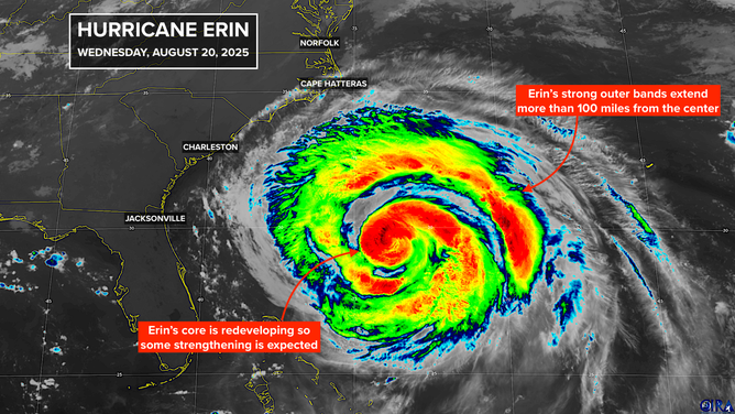
This satellite image shows Hurricane Erin on Aug. 20, 2025.
(FOX Weather)
Thankfully, the highest winds will stay out over the ocean. But strong feeder bands extend out near the periphery of the storm. The edge of the circulation is forecast to brush Cape Hatteras and extreme eastern North Carolina late today and early tomorrow.
Tropical Storm Warnings (for sustained winds over 40 mph) and Storm Surge Warnings are in effect for the coastal communities in eastern North Carolina. The danger will not be from the wind, however – it will be from the ocean.
Large-diameter storms put exponentially more energy into the ocean and therefore produce extremely dangerous currents and powerful damaging waves. Erin's energy will reach the Southeast coast today and slowly migrate north tonight and tomorrow. Many beaches will be closed due to the dangerous waves and currents. Pay attention to local instructions and check with a lifeguard before going into the ocean above your ankles.
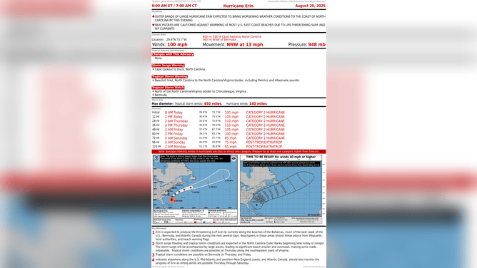
This graphic shows the latest advisory for Hurricane Erin on Aug. 20, 2025.
(FOX Weather)
On Thursday, as Erin moves north, the focus of the energy will be from Cape Hatteras north to New England – including the Tidewater of Virginia, the Delmarva Peninsula, the Jersey Shore, Long Island and the New England coast. New York City has already closed the beaches to swimming in advance of impacts from the storm, along with many other communities.
Erin will be moving out to sea by late Friday, but the ocean will still be disturbed on Saturday. It takes time for the huge amount of energy a giant storm imparts to the water to dissipate.
Next in the tropics
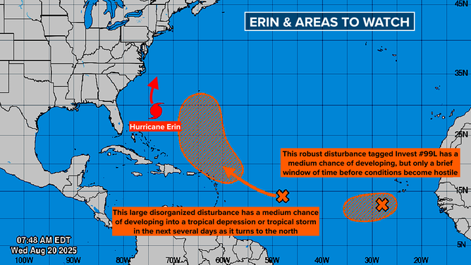
This graphic provides an overview of the tropical Atlantic Basin on Aug. 20, 2025.
(FOX Weather)
The National Hurricane Center is giving the large, disorganized disturbance two-thirds of the way between Africa and the Caribbean a medium-high chance of developing over the next few days. The consensus of the various computer forecasts is that the system will be in the vicinity of the northeastern Caribbean islands Friday or Saturday.
None of the computer model predictions show an especially strong system, but a number show a depression or Tropical Storm Fernand. If this system does develop, it looks most likely to happen after it has turned north of the islands, but we'll have to watch to be sure.
Most of the long-range forecasts indicate that the system will turn sharply north and more or less follow Erin, although many of the tracks are east of Bermuda, far from the U.S. That's certainly not 100% because it depends on how strong the system becomes and when, but the steering pattern looks strong.
The system called Invest 99L
Closer to Africa, a more organized disturbance that the National Hurricane Center tagged Invest 99L is slowly moving across the tropical belt. The NHC now has odds in the medium range that this system will develop into a tropical depression or a tropical storm.
The consensus of the computer forecasts is that hostile conditions will soon develop in its path, which will prevent it from developing if things don't come together pretty quickly.
The fundamental rule applies to both these systems: all forecasts for undeveloped or just developing systems are subject to large errors and are likely to change. So don't hang your hat on anything yet.
The big picture
A strong fall-like cold front will push toward the eastern U.S. over the week, which will keep any tropical systems well off the East Coast for a while. So after this week, we won't expect any threats from storms moving south to north for a week or more.
Even though it feels like we've been at this for a while, in reality, we're just beginning the time of year that we watch for systems developing from African disturbances. We've got a long way to go.