Bryan Norcross: Hurricane Erin is on track to stay offshore but US East Coast faces impacts
FOX Weather Hurricane Specialist Bryan Norcross says powerful Hurricane Erin will put a tremendous amount of energy into the ocean, which will be felt along all coastlines from the Caribbean to Canada, including the Bahamas and the U.S. East Coast.
Bryan Norcross: Massive waves, rip currents expected along US East Coast from Hurricane Erin
FOX Weather Hurricane Specialist Bryan Norcross has expert analysis breaking down the latest with Hurricane Erin and how the monster storm is expected to impact the U.S. this week.
Updated at 9:30 a.m. ET on Sunday, Aug. 17, 2025
The atmospheric conditions came together in a stunning way yesterday to support Hurricane Erin, suddenly blowing up into a Category 5. It was one of the fastest intensifications ever observed, and the second-lowest pressure ever recorded in an August hurricane after Hurricane Allen in 1980.
The storm is tracking west about 150 miles offshore of Puerto Rico. Erin will turn north before reaching the Bahamas and split the gap between North Carolina and Bermuda before heading out to sea. We are extremely fortunate that the weather pattern has come together to create a path for this storm that avoids direct impact on land.
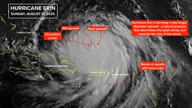
Satellite imagery of Hurricane Erin.
(NOAA)
Erin's top winds have weakened, so the storm is now a Category 3. It's going through a natural process that develops a new larger eyewall structure and expands the size of the storm. Bands of squalls rotating into Erin's center will continue to cause intense tropical downpours across the islands as the hurricane moves by to the north.
The powerful hurricane will put a tremendous amount of energy into the ocean, which will be felt along all coastlines from the Caribbean to Canada, including the Bahamas and the U.S. East Coast.
Erin's intensity is likely to fluctuate as more eyewall replacement cycles and other external influences affect the storm. It is forecast to intensify again as it's turning north well east of the Bahamas. The hurricane will also grow in size. As the circulation diameter gets larger, the peak winds normally diminish because the energy in the system is spread out over a larger area.
The larger diameter storm, however, will move more water and make stronger currents that impact the coast.
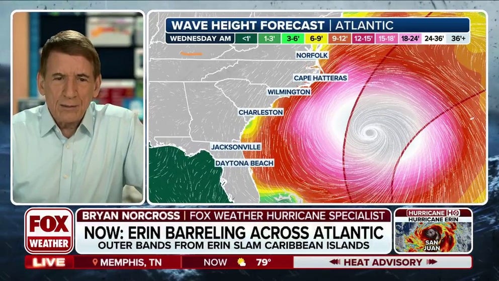
Beach conditions will be affected in Florida and along the Southeast coast on Tuesday, with peak impacts moving north through the mid-Atlantic to New England on Wednesday and Thursday. By Friday, the storm should be moving out to sea, and the weekend along the beaches looks fine.
This map is a computer prediction of the height of the waves offshore, but it’s a good indication of how the energy from Erin will spread out. Noticed the peak energy Thursday morning is focused between Cape Hatteras and southern New England.
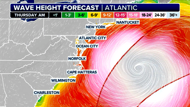
Wave height forecast for the U.S. East Coast.
(FOX Weather)
Anybody planning on going to the beach or boating this week should pay close attention to instructions from harbormasters and lifeguards. The currents will be unusually strong until Erin moves well out to sea.
Most of Erin's effects in Florida will be from Palm Beach County north to the Georgia border. The Bahamas act as a block, which diminishes the energy from a storm in South Florida. But it will still be noticeable along the beaches, so beware of the possibility of rip currents.
Remember the rule if you're caught in a current that's pulling you out: swim parallel to the beach, and soon you'll be able to swim ashore.
Eastern North Carolina, the Virginia Tidewater and the Delmarva Peninsula are the most likely locations in the U.S. to feel fringe effects from Erin’s winds around Wednesday. Nothing severe is expected, but you’ll likely know that a strong storm is offshore.
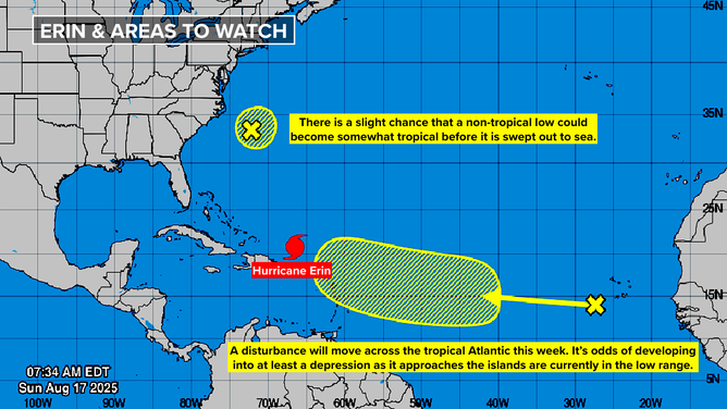
Offshore of North Carolina
The National Hurricane Center is still painting a low-probability lemon offshore of Cape Hatteras. A non-tropical low-pressure system has a slight chance of taking on some tropical characteristics today or tomorrow before it's swept out to sea.
It could briefly become a depression, and there's a very slight chance it will get a name. In any case, it will not affect land.
A new area to watch.
(NOAA)
The next African system to watch
Some computer forecast models continue to show a disturbance currently in the eastern Atlantic developing enough by the end of the week to be a disruptive system at some point in the future. The National Hurricane Center is painting a large potential development area for later in the week when the disturbance is expected to be approaching the Caribbean islands.
There is no consensus in the various computer forecasts about what will happen beginning next weekend. A number of the predictions take the system north following Erin. Some take it west into the islands. We'll need the disturbance to develop a bit before the computer models can make more consistent forecasts.
We don't discount these kinds of forecasts automatically this time of year because it's exactly the kind of system that can cause problems. It will bear watching over the next few days.