The Atlantic looks quiet through next week; Hurricane HQ&A with Bryan Norcross today at 4 p.m. ET
We’ll be live Friday at 4:00 p.m. ET taking your questions and testing our system that we plan to deploy if there’s a significant hurricane threat. I hope to see you later today on my Facebook page or FOX Weather’s Facebook, YouTube or TikTok channels.

FOX Weather is your Hurricane HQ.
(FOX Weather)
Updated Friday 1:00 p.m. ET
A robust tropical disturbance will move across the northeast Caribbean islands starting later today and through the weekend. Gusty squalls are likely and local flash flooding is possible. If the tropical Atlantic weren't so dusty and dry, this system would likely have developed into a tropical storm or a hurricane.
The obvious circulation visible by satellite is being choked by dust and dry air. Enough moisture remains, however, to bring tropical downpours to the islands.
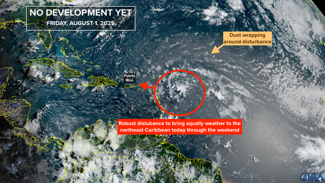
This is satellite imagery showing a disturbance near the northeast Caribbean Sea.
(CIRA)
The computer forecast models disagree on where the moisture goes next. Some forecasts pull it north toward a very wet front draped across south Georgia and northern Florida. Others take the blob of moisture toward the Florida Peninsula, and the Gulf. In any case, the odds of any development are very low.
The current long range, computer forecasts give the next disturbance, which is forecast to come off Africa about Monday, a little better chance of developing. But atmospheric conditions across the Atlantic continue to be hostile to significant development.
There are signs the general atmospheric pattern will become more conducive to development week after next – toward the middle of the month. But we’ll have to see how the various positive and negative factors work against each other as we approach the traditionally busy part of the hurricane season.
In the Pacific
The explosion of tropical activity that peaked early this week is shifting closer to Mexico. The strongest storm is Tropical Storm Gil, which is heading in the general direction of Hawaii. Its intensity will peak soon, however, because the ocean water temperature falls off quickly on its path. No significant effects are expected in the islands, although they'll notice a change in the trade winds when the remnants of Gil pass by next week.
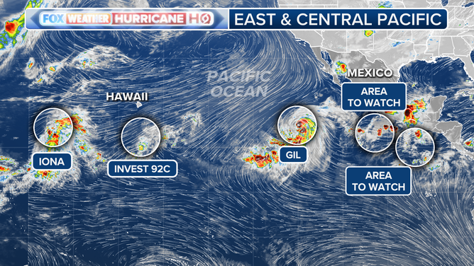
Pacific Tropics Overview
(FOX Weather)
The large-scale atmospheric pattern that supported the outbreak of tropical development in the central and eastern Pacific appears to be slowly migrating toward the Gulf and the Caribbean. This is the change in the general atmospheric pattern I mentioned above. If the supportive pulse maintains its intensity, we could see an increase in activity in the Atlantic in 10 days to two weeks. But we'll see.
Hurricane HQ&A - Watch live at 4:00 p.m. ET

We had planned to do a live Q&A session yesterday afternoon on Facebook, YouTube, and for the first time, TikTok. The extreme rainfall and flooding threat in the Mid-Atlantic and Northeast caused us to postpone it, however.
WATCH FOX WEATHER ON YOUTUBE
Now we’ll be live this afternoon (Friday) at 4 PM ET taking your questions and testing our system that we plan to deploy if there’s a significant hurricane threat. I hope to see you later today on my Facebook page or FOX Weather’s Facebook, YouTube or TikTok channels.