Bryan Norcross: Computer forecasts increasingly show a Florida Gulf Coast threat next week
The questions are: when will the upper winds allow it to consolidate into an organized circulation, and how strong will the system be when it reaches the Gulf coast of Florida?

FOX Weather is your Hurricane HQ, streaming free 24/7.
(FOX Weather)
UPDATED Friday at 9 a.m. ET
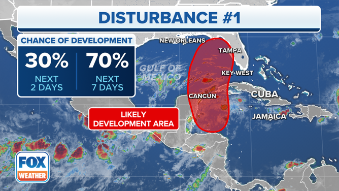
There is a general consensus among the most reliable computer forecast models that a broad, disorganized disturbance over Central America will move north into the western Caribbean Sea over the weekend and then north into the Gulf of Mexico.
The questions are: when will the upper winds allow it to consolidate into an organized circulation, and how strong will the system be when it reaches the Gulf coast of Florida? The sooner it can organize, the stronger it could become over the warm waters of the Gulf.
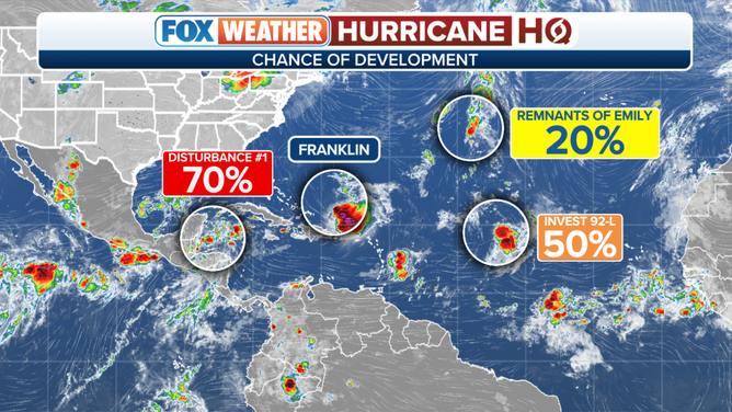
The National Hurricane Center is saying it will likely develop. But those are NOT the development odds of a dangerous storm in the Gulf, but only a tropical depression, which is a low bar.
The atmospheric pattern over much of the Gulf is forecast to be hostile to development. The position of the hostile upper-level winds when the system moves north will determine whether an organized tropical storm or hurricane can develop, or the system is more of a moisture surge. The latest forecasts increasingly show the system organizing, but to varying degrees.
The tropical outlook for the Atlantic Ocean as of Aug. 25, 2023.
(FOX Weather)
The computer forecast models that predict an organized storm predict that a band of conducive atmosphere will set up off the coast of Florida. That would give the system an opening to intensify before it makes landfall somewhere on the west coast. Other models show the path north covered by upper winds that are at least somewhat hostile to development. So organization and intensification would be slower.
This situation is fraught with forecasting and communications challenges. The atmospheric pattern will be one that allows systems to intensify very quickly if the hostile upper winds stay just far enough away from the circulation. In addition, the track would more or less parallel the Florida coast, so a slight difference in the track's angle will change where the center of the storm makes landfall by a significant distance.
Right now, most computer forecasts show the center of the system making landfall in the northern half of the Florida west coast. But even if that happened, effects would extend well south.
An area being monitored for tropical development in the Caribbean Sea.
(FOX Weather)
We don't know what name it might get yet. The next two names on the list are Idalia and Jose. There's a chance the system in the eastern Atlantic might jump in front of this one, assuming they both get named.
Whether the system develops or not, the current schedule shows the system in the vicinity of the Florida west coast Tuesday or Wednesday. The farther north it tracks over the warm Gulf waters, the stronger it might become, and the longer it will take to get to the coast.
Obviously, everybody wants to know what's going to happen. But there is only marginal consensus in the computer forecasts that we rely on. For now, we have to treat a significant storm, possibly a hurricane, making landfall on the west coast of Florida as a possibility we need to be ready for… pending more information.
A system bringing heavy rain, gusty winds, and some level of storm surge along a stretch of the Florida west coast seems likely. Beyond that, there is nothing definitive to say.
Over the weekend, we'll see what organizes, or doesn't. Forecasts for undeveloped systems are always iffy and subject to change, so nobody should read more into any one projection than science can deliver. When and if the system organizes, we can have more confidence. Stay tuned and stay informed.
In the Atlantic, Tropical Storm Franklin is still forecast to intensify. It's expected to become a hurricane over the weekend. It looks likely to track between Bermuda and the East Coast of the U.S. Be careful at the beaches. Very large swells and rip currents are likely. On Bermuda, they'll know a storm is passing by, but it shouldn't be a big issue.
The two systems in the eastern Atlantic are still trying to organize. Whatever happens, they will drive into the open ocean and are not a threat.