Fiona continues to inundate Puerto Rico with torrential rain as it pounds the Dominican Republic
The center of Fiona just clipped the southwestern corner of Puerto Rico yesterday before making a beeline for the most eastern point in the Dominican Republic overnight.
The podcast Tracking the Tropics with Bryan Norcross is now available to stream.
(FOX Weather)
Updated at 9 a.m. ET
Hurricane Fiona continues its assault on Puerto Rico, even as the center of the storm has made landfall in the Dominican Republic.
More destructive flooding, mudslides, and rockfalls are likely as the main comma-shaped feeder band of moisture rotating into the center of Fiona collides with the 4,000-foot mountains down the spine of Puerto Rico.
The geometry of the moisture band, Fiona's location, and the storm's slow movement create a worst-case scenario for the southern and eastern parts of the island. It appears likely that peak rainfall amounts will exceed 30 inches, with widespread areas receiving over 15 inches.
The torrential rain falling at the high elevations of Puerto Rico's La Cordillera Central mountain range will channel into the rivers and streams and en masse flow toward the coast. The swollen torrents will continue to sweep away bridges, buildings, trees and anything else in the way. It's a devastating scenario.
HOW TO DOWNLOAD THE FOX WEATHER APP
Fiona came at the end of an unusually wet period, so the ground was already nearly saturated. As Fiona pulls away to the north this week, the intensity of the moisture feed will only slowly relax over Puerto Rico and the surrounding islands. The atmospheric moisture level is forecast to return to normal around Thursday.
The saturated soil also made it easier for the winds to topple trees, which likely added to the issues with Puerto Rico's power system.
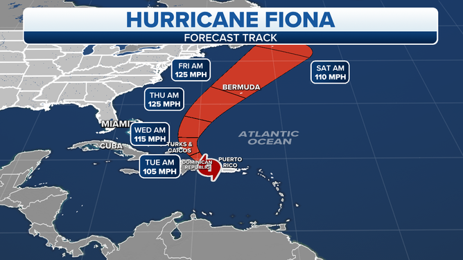
The latest Hurricane Fiona track as of 8 a.m.
(FOX Weather)
Before reaching Puerto Rico, the same moisture feed on the back side of Fiona inundated the eastern Caribbean island of Guadeloupe with some 20 inches of rain. The damage there rivaled that of Tropical Storm Erika, which caused devastation on Dominica, the island just to the south, in 2015.
The center of Fiona just clipped the southwestern corner of Puerto Rico Sunday before making a beeline for the most eastern point in the Dominican Republic overnight. In a surprise, the center tracked along the extreme left side of the cone as it intensified over the Mona Passage, the strait of water between Puerto Rico and the D.R. It was hoped that Fiona would continue lifting north and only skirt the Dominican Republic coast. But it jogged left, and the large resort city of Punta Cana took a direct hit from the strong right-side winds in the circulation.
HOW TO WATCH FOX WEATHER ON TV
This slight change in path means more rain will fall over the eastern Dominican Republic, enhanced by the mountains on that island. Rainfall totals are forecast to reach 15 inches there.
It's not clear why that western jog happened. Storms sometimes do unexpected things in the vicinity of mountains because wind flow can be deflected, but that's only speculation. That's why we use the cone, of course, to depict uncertainty in the forecast, but it was still a surprise.
The jog to the west also means that Fiona will track over or near the Turks and Caicos Islands and the southeastern Bahamas. Full preparations should be underway for the arrival of the hurricane tonight. The future track takes the center of the storm near Bermuda late Thursday or early Friday as well.
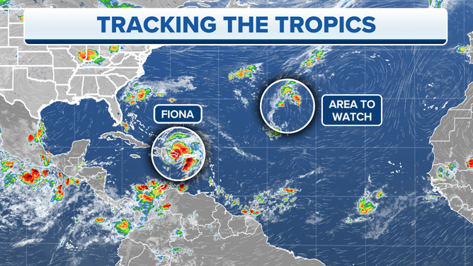
Hurricane Fiona and one area to watch in the Atlantic Ocean.
(FOX Weather)
Elsewhere in the central Atlantic, a disorganized disturbance has a slight chance of developing, but the odds are low.
Nothing else appears imminent. As we get toward the end of September, we'll start watching the western Caribbean more closely for development.
FOX Weather Hurricane Specialist Bryan Norcross has a podcast, Tracking the Tropics with Bryan Norcross, available now on FOX News Audio. You can get it on your device by clicking here.