Earl continues to strengthen, disturbances roll off Africa and Kay to break Southern California heat wave
Hurricane Earl's core is likely to pass offshore to the east of Bermuda with the hurricane-force winds about 50 miles away. Even if that happens, they’ll feel the impact of the storm.
The podcast Tracking the Tropics with Bryan Norcross is now available to stream.
(FOX Weather)
Updated at 9:30 a.m. EDT
Hurricane Earl has steadily strengthened despite the hostile upper winds and dry air impacting the system. It is interesting that some tropical systems fight back again the same hostility that gums up the circulation of many tropical storms and hurricanes. In any case, the atmospheric environment is forecast to become conducive for Earl to strengthen further and to grow in diameter as it approaches Bermuda late tomorrow into Friday.
The Bermuda Weather Service has issued a Tropical Storm Warning for the island, even though Earl is forecast to be at Category 3 strength when it’s in the vicinity. The current thinking is that the core of the hurricane is likely to pass offshore to the east with the hurricane-force winds about 50 miles away. But even if that happens, they’ll feel the impact of the storm.
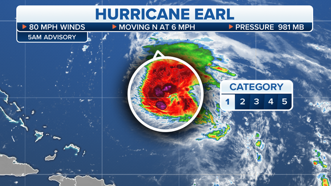
The current status of Hurricane Earl.
(FOX Weather)
They have a lot of experience with hurricanes in Bermuda, and the island is well fortified. They have through daytime tomorrow to watch Earl’s progress and be sure it stays on the forecast track.
HOW TO WATCH FOX WEATHER ON TV
Hurricane Danielle is the "Energizer Bunny" of North Atlantic hurricanes. It keeps going and going, despite its extremely high latitude. There is a tongue of unusually warm water under the storm, which is providing its energy. Danielle is setting records for the strongest winds for the longest time that far north.
The weather pattern that has been trapping it is forecast to break down today, and Danielle will quickly run into cold ocean water as it heads farther into the North Atlantic. A wave of moisture from Danielle is forecast to sweep toward Europe over the weekend.
Hurricane Kay is in the Pacific off the coast of Mexico’s Baja California. It’s forecast to track north just offshore and die out in the colder waters near the Mexico/California border. A slug of tropical moisture is forecast to continue north into Southern California bringing desperately needed rain from the desert to the sea and over much of the Southland.
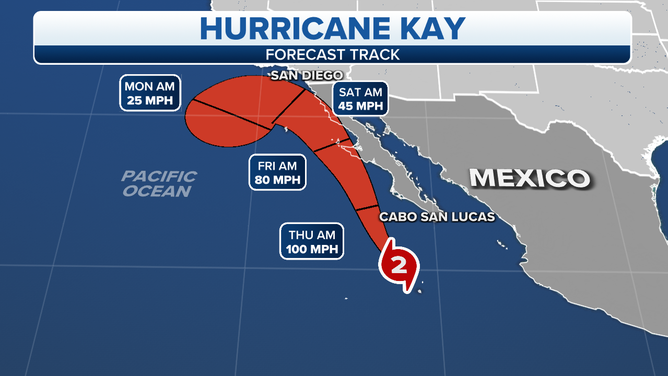
The projected path and intensity of Hurricane Kay.
(FOX Weather)
This scenario is of double-barreled benefit. There won’t be enough rain to break the decades-long drought, but any rain will help. The clouds and rain will also end the relentless heatwave that has set records for the duration. The unusual tropical airmass will stay in place well into next week.
HOW TO DOWNLOAD THE FOX WEATHER APP
Tropical Disturbance #1 appears likely to develop into at least a tropical depression, and there’s a good chance it will become a tropical storm, at least briefly. It’s forecast to turn north, however, and follow Earl in the North Atlantic.
Tropical Disturbance #2 is worth watching because it is likely to take a more southerly track across the tropical Atlantic. The National Hurricane Center is giving it a slight chance of developing in the next five days, but it’s just coming off Africa. We’ll be watching it for a while.
Our focus for the foreseeable future is on the disturbances coming off Africa and the weather pattern across the Atlantic that drives storms to the west. So far, there’s been a big gap in the high pressure that has allowed systems to turn to the north well before reaching the Bahamas or the U.S. We’ll be watching to see if that flow structure continues.
FOX Weather Hurricane Specialist Bryan Norcross has a podcast, Tracking the Tropics with Bryan Norcross, available now on FOX News Audio. You can get it on your device by clicking here.