Bryan Norcross: Tropical Depression 3 forecast to become hurricane as it heads toward Caribbean
On the current schedule, likely-Bret will arrive in the vicinity of the northeastern Caribbean Islands Thursday or Friday.

Generic Hurricane HQ
(FOX Weather)
Tropical Depression 3 was designated by the National Hurricane Center when Invest 92L attained enough organization to be upgraded. The system is forecast to become Tropical Storm Bret in the next day or so and then reach hurricane strength as it gets closer to the Caribbean.
It is important to note that the forecasts for this system have higher-than-normal uncertainties associated with them, however. The computer forecast models are divergent around Thursday. In addition, it’s very unusual to have a tropical storm, let alone a hurricane, moving through the tropical Atlantic in June. Experience tells us that some of the negative factors that keep this from usually happening have a good chance of coming into play.
Everyone in the northeastern Caribbean islands, including Puerto Rico and the Virgin Islands, needs to stay well-informed this week.
In Tropical Depression 3, we see slight curvature to the band of thunderstorms on the north side of the system. In addition, there is plenty of moisture around it, and the ocean below is unusually warm for June.
The atmospheric pattern is not perfect, but it’s not entirely hostile either. The computer forecast models are near unanimous that the system will continue to develop as it heads to the west in the direction of the Caribbean islands.
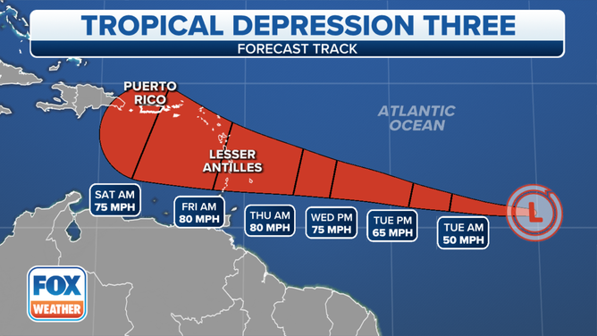
The cone of uncertainty for Tropical Depression 3 in the Atlantic.
(FOX Weather)
When the NHC determines that 40 mph winds have developed in the circulation, the system will be designated Tropical Storm Bret. Satellite data indicate that that could happen anytime.
On the current schedule, likely-Bret will arrive in the vicinity of the northeastern Caribbean Islands Thursday or Friday.
The future intensity is an open question. There is a lot of dry air forecast over the Caribbean, and the upper-level winds will slowly become more hostile.
The indications are, however, that the system will curve north near the islands if it develops into a strong tropical storm or becomes a hurricane as forecast. A weaker system would stay farther south. The National Hurricane Center forecast is a compromise.
The divergence in the track possibilities is related to the system’s speed of movement and how it interacts with the dry air and generally a more-hostile environment when it gets to the vicinity of the islands. In other words, the intensity and the track seem to be closely linked.
If the system tracks into the Caribbean, the current forecasts show the atmospheric pattern becoming quite hostile, so it should encounter tougher sledding if it gets to the waters south of Puerto Rico.
There is no threat to the U.S., the Bahamas, or surrounding areas.
Behind Tropical Depression 3/likely-Bret, the new Invest 93L is given a decent chance of developing into at least a tropical depression at this point. The atmospheric pattern over this system is a bit more conducive for development than it has been over soon-to-be Bret. So this disturbance might organize into a tropical depression more quickly. However, early indications are that it will battle more dry air downstream, which might limit its potential strength.
The computer forecasts show this system following Bret across the tropical Atlantic. How the atmosphere behind likely-Bret evolves will dictate its future. There is no indication at the current time that it would threaten land.
Around the world, the global oceans and large bodies of water have suddenly dramatically warmed to record levels – including around the British Isles, the Baltic Sea, the Mediterranean, and, importantly for us, the far eastern Atlantic. It isn’t clear why, but it is very likely to affect weather patterns on the planet. Expect unusual weather for the foreseeable future.