Watching for development near Bahamas with effects along much of East Coast
A strong, sharp dip in the jet-stream wind flow will sharpen as the flow turns sharply north near Puerto Rico. The base of that sharply turning snake of fast-moving air is forecast to break off into a large upper-level disturbance over the weekend.
The podcast Tracking the Tropics with Bryan Norcross is now available to stream.
(FOX Weather)
Updated at 9:40 a.m. Eastern
A strong, sharp dip in the jet-stream wind flow about 20,000 feet up in the atmosphere is diving due south from New England through the Bahamas into the northern Caribbean. Over the weekend, the dip will sharpen as the flow turns sharply north near Puerto Rico. The base of that sharply turning snake of fast-moving air is forecast to break off into a large upper-level disturbance over the weekend.
When the air is sharply turning aloft, often a surface low-pressure system forms in a top-down process due to the cold air being pulled south by the jet-stream wind flow and the warm air being scooped north. We’re calling this possible low-pressure development Potential Disturbance #2.
This is the opposite of what happens with a tropical system. In that case, the energy comes from the heat in the ocean water below. Development is bottom-up.
The surface low pressure that develops related to the upper-level disturbance is the system we’re interested in. It will start as a non-tropical nor’easter-type system. It could be somewhat tropical as it drifts over the warm waters around the Bahamas and Florida into next week.
A graphic showing an overview of the tropical Atlantic Ocean.
(FOX Weather)
Tropical systems have a core structure that allows them to strengthen - that’s why we’re interested in them. Although, the transition process with this system would be very slow if it happens because the upper-level environment is expected to be marginal for development.
Whatever happens with Potential Disturbance #2, the broad area of low pressure over Florida and the Bahamas is forecast to work with the strong high-pressure system off New England next week to produce a wide corridor of strong onshore winds along most of the U.S. East Coast from Florida through the Mid-Atlantic.
The National Hurricane Center is giving the non-tropical low-pressure system that develops over the weekend a medium chance of developing some tropical characteristics as it drifts over the Bahamas or Florida.
No strong storm is expected out of this, but nasty wet and windy weather for many people along the U.S. East Coast appears likely next week.
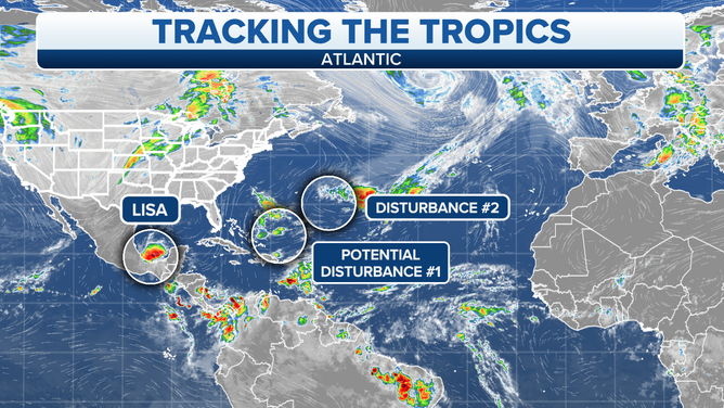
Farther north, Disturbance #2 is a small non-tropical system that has a very slight chance to develop into something tropical over the next day or so as it moves in the general direction of Bermuda. After that, it is forecast to get absorbed by the much bigger system to the south.
These messy non-tropical transition systems are often the type we watch this time of year. Pockets of unusually warm ocean water seem to be contributing to their development. Hopefully, Mother Nature will calm down after next week, but we’ll see.
What’s left of Lisa is now Tropical Depression Lisa. The system is drifting over the extreme southern Gulf of Mexico under hostile upper winds. It is forecast to die out in a day or so.
FOX Weather Hurricane Specialist Bryan Norcross has a podcast, Tracking the Tropics with Bryan Norcross, available now on FOX News Audio. You can get it on your device by clicking here.