Bermuda is carefully watching Earl while new disturbances move off Africa
On average, most hurricanes occur in the second half of the hurricane season, so we have to be vigilant in spite of the unusually slow season so far.
The podcast Tracking the Tropics with Bryan Norcross is now available to stream.
(FOX Weather)
Updated at 9:30 a.m. EDT
Tropical Storm Earl is sputtering a bit. Its circulation is being injected with dry air by hostile upper winds. The environment is forecast to become much more conducive for Earl to organize in the next couple of days. However, Earl is predicted to be a strong hurricane when it makes its closest approach to Bermuda on Thursday or early Friday.
The exact impacts on Bermuda are unclear, but the island is well within the cone. Since Earl is forecast to grow in size as well as strength, the odds are increasing that Bermuda will feel the storm's effects. A tropical storm or hurricane watch will likely be issued for Bermuda tonight.
Earl’s moisture tail is still over the Virgin Islands and surrounding areas, so tropical downpours are still possible there. They will decrease as Earl pulls away to the north.
HOW TO WATCH FOX WEATHER ON TV
After Earl passes Bermuda, it will head into the North Atlantic and eventually be absorbed into another northern weather system.
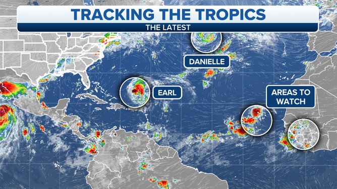
Hurricane Danielle and Tropical Storm Earl are both roaming the Atlantic Basin on Tuesday, Sept. 6, 2022.
(FOX Weather)
Hurricane Danielle is on a slow path toward evolving into a northern-type storm over increasingly cool water in the North Atlantic. It will merge with another northern system in a few days. Its moisture will eventually affect Europe.
Tropical Disturbance #1 is showing some signs of organization as it tracks across the tropical Atlantic. As it moves to the west, likely-Hurricane Earl will be tracking north and east. Earl’s low pressure should provide a path north in the central Atlantic, so this disturbance is not expected to be a threat to land.
Disturbance #2 is still over Africa, but the National Hurricane Center is making note of it because it has the potential to develop at the end of the week or early next week once it’s over the tropical ocean.
HOW TO DOWNLOAD THE FOX WEATHER APP
The long-range computer forecast models predict that the weather pattern over the Atlantic will evolve next week, so disturbances will be less likely to turn north in the middle of the ocean. For several weeks now, one low-pressure system or another has occupied the western Atlantic. This has provided a path north for the disturbances that have come along. But once Earl is gone, there are indications that high pressure will spread west in a more normal configuration.
As a general statement, that so-called Bermuda high is the block that keeps disturbances from immediately turning north. So we’ll pay more attention to the systems coming along next week and beyond.
On average, most hurricanes occur in the second half of the hurricane season, so we have to be vigilant in spite of the unusually slow season so far.
FOX Weather Hurricane Specialist Bryan Norcross has a podcast, Tracking the Tropics with Bryan Norcross, available now on FOX News Audio. You can get it on your device by clicking here.