Bryan Norcross: Atlantic tropical disturbance Invest 94L still has a good chance to develop this week
The current thinking is that after another day or two, the odds the disturbance will organize into at least a tropical depression will increase. The National Hurricane Center is giving the system a high chance of some development after Wednesday.

FOX Weather is your Hurricane HQ, streaming free 24/7.
(FOX Forecast Center / FOX Weather)
Updated at 9:30 a.m. Monday
The tropical disturbance about midway between the coast of Africa and the Caribbean Sea – officially named Invest 94L – is a broad bulge in a quasi-permanent elongated area of low pressure spread across the southeastern tropical Atlantic. The extended zone of thunderstorms is called the Intertropical Convergence Zone (ITCZ) or the Monsoon Trough.
The "Convergence Zone" refers to the tropical wind flowing from the North Atlantic and the South Atlantic colliding in this elongated area. "Monsson Trough" comes from "monsoon," which means "seasonal," and "trough," which means "low pressure." This area is along the southern border of the tropical development zone during hurricane season, but it moves away as the Sun moves farther south.
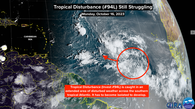
A satellite image of Invest 94L in the central tropical Atlantic Ocean on Monday, October 16, 2023.
(NOAA)
Disturbances often struggle to break free of the stretched-out area of low pressure, and this tropical disturbance/Invest 94L is no exception. Until the system can become isolated so the winds flowing into the system are not disrupted by surrounding clusters of thunderstorms, it will struggle to organize.
The current thinking is that after another day or two, the odds the disturbance will organize into at least a tropical depression will increase. The National Hurricane Center is giving the system a high chance of some development after Wednesday.
On the current schedule, the system will be in the vicinity of the northeastern Caribbean on Friday or Saturday.
The question remains how strong the disturbance will become by the time it is near the islands. The consensus of the computer forecasts is that the atmospheric pattern will NOT be conducive for a strong storm in and around the northeast Caribbean. And if the storm strengthens sooner than expected, it would likely turn north before reaching the islands.
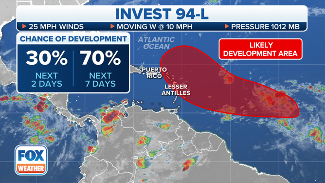
The development chances of Invest 94L in the central tropical Atlantic Ocean.
(FOX Weather)
As always with a system that has not yet developed, however, forecasts are highly uncertain and subject to change. All we can say currently is that the odds favor the effects on the islands being from a relatively weak storm or maybe just a moisture surge when the system tracks near or over the islands late in the week. But if and until the disturbance can break out of the ITCZ, confidence in the forecast will be low.
Everybody in the islands should stay up to date on the latest forecast this week.
To the north, the system that was Tropical Storm Sean is now just a cluster of thunderstorms. The circulation has dissipated.
Next week, we’ll keep an eye on the western Caribbean and the southern Gulf of Mexico, although the current consensus is that development is more likely on the Pacific side of Central America.