Bryan Norcross: Atlantic's Invest 94L showing some signs of development as it heads west
The National Hurricane Center is giving the disturbance a medium chance of developing into at least a tropical depression in the next couple of days and a high chance of developing after that.

FOX Weather is your Hurricane HQ, streaming free 24/7.
(FOX Weather)
Updated at 9 a.m. EDT on Tuesday
The tropical disturbance we have been following – officially tagged Invest 94L – is a large area of cloudiness and poorly organized thunderstorms. Some curvature is developing in the main band of thunderstorms, however, which is usually a sign the system is trying to organize.
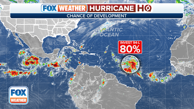
A broad area of low pressure located over the central tropical Atlantic about 1,100 miles east of the Windward Islands continues to produce a large area of disorganized showers and thunderstorms.
(FOX Weather)
The atmospheric pattern is only marginally conducive for development. Upper-level winds are blowing across the system, although they are not so strong that a circulation shouldn’t be able to form. When a system is large, however, the process can be slow. It takes time to get the air moving in the same direction around a large tropical system.
The National Hurricane Center is giving the disturbance a medium chance of developing into at least a tropical depression in the next couple of days and a high chance of developing after that.
The computer forecasts are in two camps. One group predicts the system will continue struggling and move quickly toward the northeast Caribbean, bringing gusty squalls to the islands late Thursday into Friday. In this scenario, the disturbance would at most develop into a tropical depression or weak tropical storm.
The other camp shows the disturbance moving more slowly and organizing into a stronger storm. In both cases, the strong dip in the jet stream that pushed the cold front across the eastern U.S. scoops the system to the north. In the slower-moving, stronger scenario, however, the system stays offshore of the islands before the northward turn.
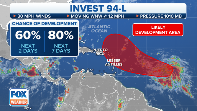
Environmental conditions are expected to remain conducive for gradual development, and a tropical depression will likely form during the next 2-3 days while the system moves westward to west-northwestward across the central and western tropical Atlantic.
(FOX Weather)
The weaker scenario seems more likely at this time because the atmospheric pattern is forecast to become more hostile near the islands, but a strong storm is still possible. In the northeastern Caribbean islands, be sure to stay informed of the latest developments over the next few days.
The cold front that pushed off the East Coast will protect the U.S. and the surrounding areas from any tropical systems coming from the Atlantic. Once this disturbance passes the islands, it will turn north and eventually dissipate or be absorbed.
Nothing else is pending at the moment. Although we always watch the western Gulf when cold fronts stall there in October.