Atlantic disturbance is showing signs of development as it heads toward the Caribbean islands
The Tropical Disturbance we have been watching in the central tropical Atlantic quickly became better organized overnight. The National Hurricane Center puts the odds at high that the disturbance will become at least a tropical depression.
The podcast Tracking the Tropics with Bryan Norcross is now available to stream.
(FOX Weather)
Updated at 9:00 a.m. Eastern
The Tropical Disturbance we have been watching in the central tropical Atlantic quickly became better organized overnight. The atmosphere cools in the nighttime hours, which causes a larger temperature contrast with the warm tropical ocean than during the day. This contrast can make thunderstorms grow, which can tighten the system's circulation.
Dry air and hostile upper winds are still in the vicinity of the disturbance. But it appears the system has found a pocket of conducive enough conditions for the disturbance to organize.
The National Hurricane Center puts the odds at high that the disturbance will become at least a tropical depression.
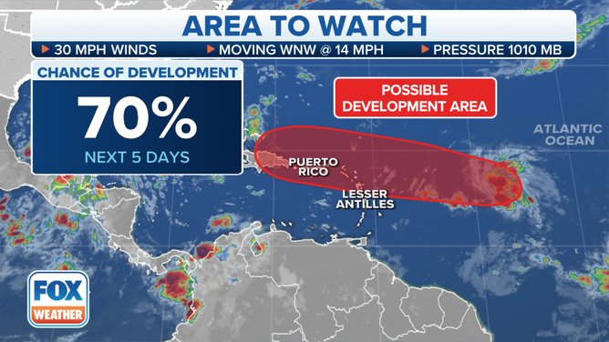
Tracking an area to watch for possible development in the Atlantic
(FOX Weather)
According to the computer forecast models, the atmospheric environment will continue to be marginal as the system moves toward Puerto Rico and the surrounding islands in the northeast Caribbean. Whether it becomes a depression or not, it will arrive in the islands late in the week and affect the weather through the weekend.
Gusty winds and heavy rain are likely, regardless of development. The ground is saturated in Puerto Rico and other mountainous islands so additional heavy rain could cause mudslides and flooding. Everybody in the northeastern Caribbean islands should stay informed of developments with this system.
Looking further downstream, there is a high consensus the system will continue west as at least a strong moisture surge across the Dominican Republic and Haiti. At some point, the evidence suggests that the system will turn north, but there are too many moving parts to know when that might happen.
How much will the disturbance organize before it gets to the islands? What shape will it be in after interacting with the mountains of Puerto Rico, let alone the giant mountains in the Dominican Republic? The answers are unknown, of course. And the organization and strength of the system will affect how it is steered.
Forecasts for any system that interacts with the mountainous islands are always subject to higher-than-normal errors. And any turn to the north wouldn't likely happen until next week.
Otherwise, we'll watch as more systems come off Africa, though no quick development is expected due to the unusually dry air over the tropical Atlantic and bands of hostile upper winds.
FOX Weather Hurricane Specialist Bryan Norcross has a podcast, Tracking the Tropics with Bryan Norcross, available now on FOX News Audio. You can get it on your device by clicking here.