Atlantic disturbance showing some signs of organization
A NOAA jet flew a research mission around the disturbance yesterday and found lots of dry air, especially in the mid-levels of the atmosphere.
The podcast Tracking the Tropics with Bryan Norcross is now available to stream.
(FOX Weather)
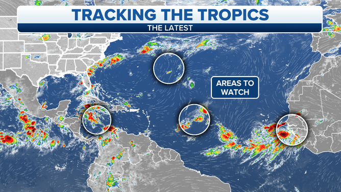
Updated at 9 a.m. Eastern: Tropical Disturbance #1: The system located between the Caribbean islands and Africa is showing some signs of consolidation, but it has a ways to go. A NOAA jet flew a research mission around the disturbance yesterday and found lots of dry air, especially in the mid-levels of the atmosphere. The environment around the system is forecast to continue to be dry. If that happens, it should slow development, though the environment ahead appears conducive enough for a tropical depression or tropical storm to form.
There is a strong consensus among the computer forecast models that the disturbance and the eventual developed tropical system will move toward the open ocean north of Puerto Rico and the northeastern Caribbean islands, and the National Hurricane Center’s potential development area reflects those projections.
The admonition that forecasts for just-developing or slow-moving systems more often have higher errors applies in this case, however. Additional uncertainty is added because this system is quite large. It’s not clear where the eventual center will form. So everybody in the northeast Caribbean should stay informed.
The so-called Bermuda High that drives tropical systems across the Atlantic is weak at the moment just to the north of the disturbance, which means it will move relatively slowly for a while. An area of low pressure from and old front to the north has dented the high making it weaker, which in theory will also allow the system to ease north of the Caribbean islands. But let’s be sure.
The tropical Atlantic overview.
(FOX Weather)
Farther along, when and if the system reaches the waters east of the Bahamas, it appears the steering currents will be weak, so we’re likely to be watching this disturbance for a while.
Potential Tropical Disturbance #2: Some of the computer forecast models insist on the possibility of a tropical system developing in the Caribbean waters just east of the Yucatán Peninsula. This potential system would result from the combination of a disturbance we’ve been tracking across the Caribbean and a broad area of low-pressure over Central America.
As is often the case with these Central American systems, the mountainous landmass introduces a forecast challenge. It’s often hard to predict whether the tropical system will spin up in the Caribbean or in the Pacific Ocean, or occasionally in both areas. This situation is no exception.
For now, residents of Belize and the Yucatán should stay informed. A system could develop quickly in the western Caribbean toward the end of the week, although it would not seem to have much time to strengthen.
Disturbance #3 is a small non-tropical low-pressure system in the open waters well east of Bermuda. It has a slight chance of evolving into a tropical system before it is absorbed into another large weather system in the North Atlantic. In any case, it won’t threaten land.
Disturbance #4 is just crossing the African coast. It has a fair chance of eventually developing into at least a tropical depression in the east Atlantic. There is no sign that it would be a threat at this time.
Interestingly, the long-range computer forecast models indicated the increase in activity across the Atlantic this week, which we’ve seen happen to one degree or the other. Now the consensus is that the Atlantic will go quiet again once these systems are gone. As always, however, we have to stay vigilant with the peak of hurricane season approaching in less than two weeks.
FOX Weather Hurricane Specialist Bryan Norcross has a podcast, Tracking the Tropics with Bryan Norcross, available now on FOX News Audio. You can get it on your device by clicking here.