10 Worst cities for air pollution in the US
More than 70% of us lived in air pollution for more than a month last year.
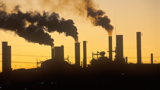
Sunset on a factory in Ohio spewing smoke and steam.
(Photo by: Joe Sohm/Visions of America/Universal Images Group via Getty Images)
A study recently named the ten worst cities to live in for air pollution.
Nearly 237.6 million Americans were exposed to more than a month of air pollution last year, Environment America, U.S. PIRG, and the Frontier Group found.
The air pollution data in their study came from daily 2020 Environmental Protection Agency, EPA, readings.
Some of the worst may surprise you.
- Los Angeles-Long Beach-Anaheim, CA – population 13,109,903
- Phoenix-Mesa-Chandler, AZ - population 5,059,909
- Riverside-San Bernardino-Ontario, CA - population 4,678,371
- San Diego-Chula Vista-Carlsbad, CA – population 3,332,427
- Denver-Aurora-Lakewood, CO - population 2,991,231
- San Antonio-New Braunfels, TX - population 2,590,732
- Sacramento-Roseville-Folsom, CA - population 122 2,374,749
- Austin-Round Rock-Georgetown, TX - population 2,295,303
- Cincinnati, OH-KY-IN - population 2,232,907
- Indianapolis-Carmel-Anderson, IN - population 2,091,019
Defining air pollution
Good air quality does vary depending on the agency.
The EPA defines acceptable ozone levels as under 70 parts per billion over 8 hours, and the World Health Organization (WHO) calls under 51 parts per billion acceptable for ozone.
The EPA says that polluting small particulate matter (dust, soot, smoke) is 2.5 microns in diameter and under. At the same time, the new WHO guidelines consider particles polluters if they are under 2.5 microns and 10 microns. WHO considers particles equal or smaller than 10 microns. THIS YEAR, the WHO new guidelines claim the 2.5 microns can enter the bloodstream while the 10-micron particulates are trapped deep in the lungs. For reference, the N95 masks trap 95% of particles 0.3 microns and greater.
Closer look:
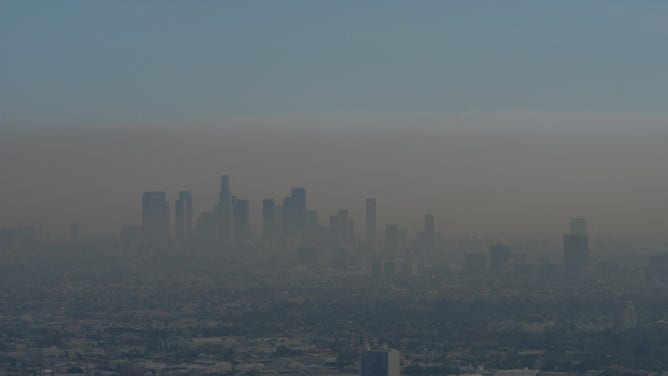
Downtown Los Angeles and Hollywood were enveloped in smog in 2004.
(Getty Images)
LA area (including Riverside, San Bernardino and Ontario): Los Angeles and surrounding areas have the worst ozone pollution in the U.S. Sunlight react with nitrogen oxides (like car and ship exhaust) and other reactive organic compounds to form ozone. The combo of ozone and particulate matter creates the smog trapped in the LA basin by surrounding mountains. Anyone flying into LAX in the summer knows the yellow haze hanging over the city. LA also doesn’t get much rain during those months to wash the particles out of the air.
Gusty winds across the deserts and wildfire smoke create more wind-borne particulates.
Farming may look green but is also a significant air-polluting factor. Crops produce pollen. Farmers use nitrogen for fertilizer which is not all absorbed. A Scientific American article reported on a study saying, "20 to 32 percent of the state’s NOx (multitude of nitrogen and oxygen molecules) emissions come from cropland, compared with 29 to 36 percent from on-road motor vehicles."
Phoenix Metro Area: This densely populated area also has a lot of traffic and sun, creating ground-level ozone. Temperature inversions are a big reason for winter pollution. This is a very stable weather scenario where warm air aloft traps cooler air at the surface for days with no wind. Here the smog accumulates and stagnates at the surface.
Phoenix also sees many wildfires and wind-blown dust from deserts.
San Diego Metro: Car exhaust tops the top air pollutant in an area with over 3.3 million people.
Denver Metro: Denver experiences temperature inversions, trapping pollutants in the winter. Large wildfires in the mountains also create smoke and particulate matter. Denver also has three coal-fired power plants.
San Antonio and New Braunfels, TX: Petroleum industries, including fracking, contribute to high ozone levels and small particulates, especially from April to October. A 2017 study prepared for San Antonio by an environmental consulting group examined city health data from 2010 to 2014, concluding that nearly 4,700 residents died due to respiratory diseases during those four years.
Sacramento Area: Large wildfires in the state are the biggest problem for Sacramento air quality. Traffic and winter temperature inversions add to the pollution. Farming is also a major industry in surrounding areas.
Austin Area: Abundant sun and lots of traffic create an ozone issue. Nearby oil and gas production also adds to the pollution.
Cincinnati, OH-KY-IN: This area has year-round high levels of small airborne particles and soot. The main culprits are unpaved roads, construction sites, automobiles and power plants.
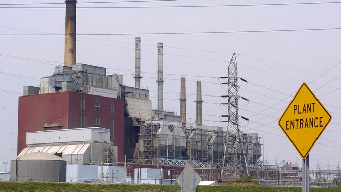
The coal-fueled power plant on the Ohio River.
(Photo by David Kohl/Bloomberg via Getty Images / Getty Images)
Indianapolis-Carmel-Anderson, IN: The main problem is air particle pollution from coal-fired power plants and cars burning fossil fuels. Look for the Office of Sustainability to issue Knozone Action Days, especially when it's warm, encouraging people sensitive to air pollution to stay inside.
The director of Indiana University's Environmental Resilience Institute said, "It takes years off your life. Particulate matter doesn't exit your lungs very quickly; it's so small, it goes deep into your lungs, and that causes lung inflammation, and eventually lung disease and cardiovascular disease."
Why is air pollution so dangerous?
WHO reports that air pollution is responsible for over 7 million premature deaths worldwide every year. Air pollution exacerbates and contributes to respiratory infections, aggravates asthma, heart disease and even strokes. Wildfire smoke can increase the risk of dementia and cancer.
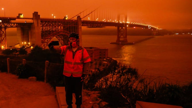
Dark orange skies over the Golden Gate Bridge at midday in San Francisco due to smoke from massive wildfires in 2020.
(Gabrielle Lurie/The San Francisco Chronicle via Getty Images)
Ozone is helpful higher in the upper atmosphere but is dangerous at ground level. Studies report it can reduce lung function by inflaming the linings of your lungs and cause chest pain, coughing and congestion. Ozone even has been blamed for widespread crop and forest damage by interfering with photosynthesis.
Does my city have damaging air pollution?
Forecasts on the FOX Weather app will show you the Air Quality Index, AQI for your area. The EPA explains the AQI as a thermometer showing the number of air pollutants in the air. This runs from 0 being healthy to 500 the most dangerous air quality. The AQI tracks the five major pollutants: ground-level ozone, carbon monoxide, sulfur dioxide, nitrogen dioxide, and airborne particles.
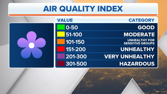
(FOX Weather)
Check your city's AQI against the chart to decide about opening windows, exercising outdoors and maybe skipping the outdoor fire.